IMAGES TAKEN NEAR TO
Catwick Lane, DRIFFIELD, YO25 8RW
Introduction
This page details the photographs taken nearby to Catwick Lane, YO25 8RW by members of the Geograph project.
The Geograph project started in 2005 with the aim of publishing, organising and preserving representative images for every square kilometre of Great Britain, Ireland and the Isle of Man.

There are currently over 7.5m images from over14,400 individuals and you can help contribute to the project by visiting https://www.geograph.org.uk
Image Map
Images are licensed for reuse under creativecommons.org/licenses/by-sa/2.0
Notes
- Clicking on the map will re-center to the selected point.
- The higher the marker number, the further away the image location is from the centre of the postcode.
Image Listing (17 Images Found)
Images are licensed for reuse under creativecommons.org/licenses/by-sa/2.0
Image
Details
Distance
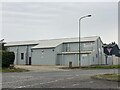
2
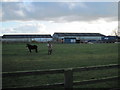
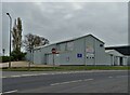
Brandesburton Industrial Estate
From the bridleway as it approaches the Bridlington road
Image: © Martin Dawes
Taken: 7 Mar 2012
0.13 miles
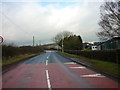
3
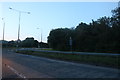
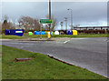
A165 approaching the Brandesburton roundabout
Image: © J.Hannan-Briggs
Taken: 13 Mar 2017
0.16 miles
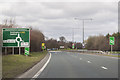
7
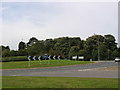
A165 Brandesburton Roundabout
The A165 runs NS along the west edge of the grid square. The majority of Brandesburton is in the adjacent square west.
Image: © Stephen Horncastle
Taken: 9 Oct 2005
0.17 miles
8
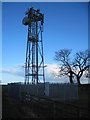
Communications Mast Brandesburton
East of the village on the bridleway to Catfoss Bridge.
Image: © Martin Dawes
Taken: 7 Mar 2012
0.19 miles
9
Recycling facility near Brandesburton
These colourful bins are located on the east side of the A165, just east of Brandesburton village.
Image: © Peter Church
Taken: 28 Mar 2009
0.20 miles
10
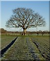
Bridleway and tree, near Brandesburton
The bridleway running east from the village takes a sharp turn at the tree seen here, rather than following the route marked on OS maps
Image: © Paul Harrop
Taken: 24 Feb 2016
0.22 miles