IMAGES TAKEN NEAR TO
Foston-on-the-Wolds, DRIFFIELD, YO25 8BS
Introduction
This page details the photographs taken nearby to YO25 8BS by members of the Geograph project.
The Geograph project started in 2005 with the aim of publishing, organising and preserving representative images for every square kilometre of Great Britain, Ireland and the Isle of Man.

There are currently over 7.5m images from over14,400 individuals and you can help contribute to the project by visiting https://www.geograph.org.uk
Image Map
Images are licensed for reuse under creativecommons.org/licenses/by-sa/2.0
Notes
- Clicking on the map will re-center to the selected point.
- The higher the marker number, the further away the image location is from the centre of the postcode.
Image Listing (8 Images Found)
Images are licensed for reuse under creativecommons.org/licenses/by-sa/2.0
Image
Details
Distance
3
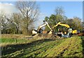
Construction site delivery at bridge over Foston Beck
Image: © Martin Dawes
Taken: 17 Nov 2021
0.12 miles
5
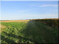
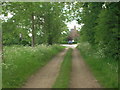
Field edge footpath toward Foston on the Wolds
Image: © Martin Dawes
Taken: 17 Nov 2021
0.21 miles
6
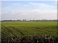
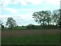
The view towards Foston
Taken from the side of the road just within the square at MR: TA08025501 looking NEE.
Image: © Andy Beecroft
Taken: 14 Feb 2006
0.22 miles
7
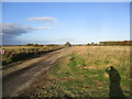
Field edge track to pipe laying site
Pipelaying is going on all over this part of East Yorkshire as the power generated by the North Sea Wind farms is brought ashore to link up with the National Grid near Beverley
Image: © Martin Dawes
Taken: 17 Nov 2021
0.23 miles
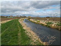
8
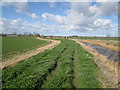
Footpath on top of flood bank Foston Beck
Buildings at Carr House Farm to the left
Image: © Martin Dawes
Taken: 13 Mar 2019
0.25 miles