IMAGES TAKEN NEAR TO
Foston-on-the-Wolds, DRIFFIELD, YO25 8BH
Introduction
This page details the photographs taken nearby to YO25 8BH by members of the Geograph project.
The Geograph project started in 2005 with the aim of publishing, organising and preserving representative images for every square kilometre of Great Britain, Ireland and the Isle of Man.

There are currently over 7.5m images from over14,400 individuals and you can help contribute to the project by visiting https://www.geograph.org.uk
Image Map
Images are licensed for reuse under creativecommons.org/licenses/by-sa/2.0
Notes
- Clicking on the map will re-center to the selected point.
- The higher the marker number, the further away the image location is from the centre of the postcode.
Image Listing (7 Images Found)
Images are licensed for reuse under creativecommons.org/licenses/by-sa/2.0
Image
Details
Distance
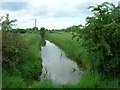
4
Trees alongside Old Howe
Old Howe is a drain.
Image: © Jonathan Thacker
Taken: 14 Dec 2018
0.08 miles
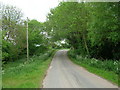
5
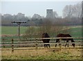
East of Foston on the Wolds
Looking west from Foston Lane, with the tower of St Andrew's Church at Foston in the distance.
Image: © Paul Harrop
Taken: 20 Mar 2015
0.08 miles
6
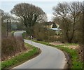
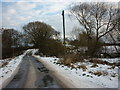
Old Howe Lane, near Beeford
The lane descends here towards the bridge in the distance across the eponymous land drain
Image: © Paul Harrop
Taken: 20 Mar 2015
0.14 miles
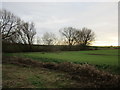
7
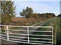
Woodhouse Farm
This grid square is all farmland. This view looking NE from the entrance to Woodhouse Farm which sits on the east edge of the square
Image: © Stephen Horncastle
Taken: 20 Nov 2005
0.20 miles