IMAGES TAKEN NEAR TO
Blueberry Close, DRIFFIELD, YO25 6SE
Introduction
This page details the photographs taken nearby to Blueberry Close, YO25 6SE by members of the Geograph project.
The Geograph project started in 2005 with the aim of publishing, organising and preserving representative images for every square kilometre of Great Britain, Ireland and the Isle of Man.

There are currently over 7.5m images from over14,400 individuals and you can help contribute to the project by visiting https://www.geograph.org.uk
Image Map
Images are licensed for reuse under creativecommons.org/licenses/by-sa/2.0
Notes
- Clicking on the map will re-center to the selected point.
- The higher the marker number, the further away the image location is from the centre of the postcode.
Image Listing (49 Images Found)
Images are licensed for reuse under creativecommons.org/licenses/by-sa/2.0
Image
Details
Distance
1

Beverley Road, Driffield
Looking towards Driffield.
Image: © Peter Church
Taken: 2 May 2009
0.02 miles
2
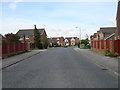
Bracken Road, Driffield
This housing estate, just off the Beverley Road on the outskirts of Driffield is typical of thousands of similar ones in the UK with its cul-de-sacs and red-bricked 'three-bed-semis'. This estate is actually nearly as large as the town itself.
Image: © Tracey Anne Hartley
Taken: 5 Oct 2009
0.05 miles
3
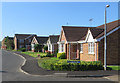
Bracken Road, Driffield
At its junction with Fern Close at the extreme south-western corner of the town.
Image: © Paul Harrop
Taken: 19 Jul 2016
0.05 miles
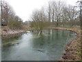
4

Driffield Beck
From the bridge on Beverley Road.
Image: © JThomas
Taken: 3 Apr 2020
0.05 miles
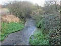
5
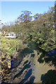
Upstream along the river Hull
The photograph was taken on Hallimanwath Bridge, and the water is very clear. The caravan is parked on the Driffield showground on the occasion of a kite festival.
Image: © Peter Church
Taken: 2 May 2009
0.05 miles
6
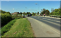
Beverley Road, Driffield, crosses Hallimanwath Bridge
The unspectacular bridge crosses the river Hull, the view here being southwest. The road is numbered A164 at this point.
Image: © Peter Church
Taken: 2 May 2009
0.06 miles
7
Driffield Beck from Beverley Road
The beck runs under the road
Image: © Martin Dawes
Taken: 1 Dec 2020
0.07 miles
8
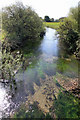
River Hull from Hallimanwath Bridge
This photograph was taken facing south-east, the direction in which water is flowing. The water was beautifully clear and inviting. The river Hull is fed from springs rising in the chalk of the Yorkshire Wolds and flowing gently south through the river Hull basin. The river here is 16 metres above mean sea level, and has 20 miles to run before it reaches the Humber.
Image: © Peter Church
Taken: 2 May 2009
0.11 miles
10
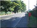
Beverley Road, Driffield
Looking north east showing position of Postbox No. YO25 317.
See Image] for postbox.
Image: © JThomas
Taken: 6 Aug 2016
0.13 miles