IMAGES TAKEN NEAR TO
Watersedge, DRIFFIELD, YO25 6PD
Introduction
This page details the photographs taken nearby to Watersedge, YO25 6PD by members of the Geograph project.
The Geograph project started in 2005 with the aim of publishing, organising and preserving representative images for every square kilometre of Great Britain, Ireland and the Isle of Man.

There are currently over 7.5m images from over14,400 individuals and you can help contribute to the project by visiting https://www.geograph.org.uk
Image Map
Images are licensed for reuse under creativecommons.org/licenses/by-sa/2.0
Notes
- Clicking on the map will re-center to the selected point.
- The higher the marker number, the further away the image location is from the centre of the postcode.
Image Listing (271 Images Found)
Images are licensed for reuse under creativecommons.org/licenses/by-sa/2.0
Image
Details
Distance
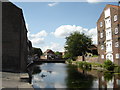
2
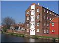
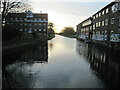
Riverhead Mill
Grade II listed. http://www.britishlistedbuildings.co.uk/101161902-riverhead-mill-driffield
Image: © N Chadwick
Taken: 1 Jan 2017
0.03 miles
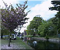
3
Riverhead, Driffield
Probably the most attractive corner of the town, the area marks the end of the Driffield Navigation and comprises residential conversions of former mill buildings as well as newer waterside properties.
Image: © Paul Harrop
Taken: 22 Apr 2011
0.04 miles
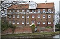
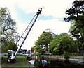
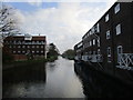
5
Driffield Canal at River Head
Mill and Warehouses are now apartments. The canal was built in 1770 and the last commercial craft was 1951, it is no longer navigable on some sections of its 11 mile length to the River Hull
Image: © Martin Dawes
Taken: 1 Dec 2020
0.04 miles
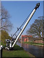
7
Canal, Driffield
Driffield is a market town that is sometimes called the Capital of the Yorkshire Wolds – it found prosperity in the late 18th century when a canal was built linking Driffield to the sea. The River Head area became a major transportation hub but as with the rest of the canal network, it was soon to be taken over by the railways. The canal is now slowly being redeveloped with the usual conversion of warehouses into canal side apartments.
Image: © Richard Rogerson
Taken: 22 Aug 2022
0.04 miles
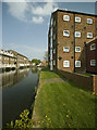
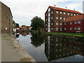
9
Riverhead Driffield
The warehouses on both sides have now been converted to apartments and flats
Image: © Martin Dawes
Taken: 4 Jul 2009
0.04 miles
10
Riverhead, Great Driffield
The basin of the Driffield Canal.
Image: © Jonathan Thacker
Taken: 18 Nov 2014
0.05 miles