IMAGES TAKEN NEAR TO
Rudston, DRIFFIELD, YO25 4XA
Introduction
This page details the photographs taken nearby to YO25 4XA by members of the Geograph project.
The Geograph project started in 2005 with the aim of publishing, organising and preserving representative images for every square kilometre of Great Britain, Ireland and the Isle of Man.

There are currently over 7.5m images from over14,400 individuals and you can help contribute to the project by visiting https://www.geograph.org.uk
Image Map
Images are licensed for reuse under creativecommons.org/licenses/by-sa/2.0
Notes
- Clicking on the map will re-center to the selected point.
- The higher the marker number, the further away the image location is from the centre of the postcode.
Image Listing (155 Images Found)
Images are licensed for reuse under creativecommons.org/licenses/by-sa/2.0
Image
Details
Distance
1
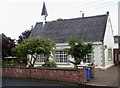
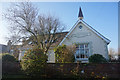
Former Rudston National School
This building, built in 1858, was originally the Rudston National School. It is now a private house which has retained the old school bell, visible above the roof.
Image: © Dr Patty McAlpin
Taken: 18 Jul 2009
0.02 miles
2
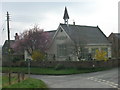
The old school, Rudston
Still has the bell on top.
Image: © Pauline E
Taken: 23 Mar 2012
0.02 miles
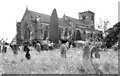
4
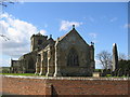
Rudston Parish Church
Rudston Parish Church of all Saints is situated on the south side of the B1253 and at the east edge of Rudston.
Image: © Stephen Horncastle
Taken: 17 Apr 2006
0.03 miles
6
The Rudston Monolith , 1979
In this image the menhir is without the lead cap to protect it from the elements. It also appears to have a picket fence surrounding it.
Image: © Harold Dilworth Crewdson
Taken: Unknown
0.03 miles
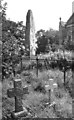
7
All Saints Church and monolith, Rudston, 1979
In this image the menhir is without the lead cap to protect it from the elements; it also has a picket fence surrounding it.
Image: © Harold Dilworth Crewdson
Taken: Unknown
0.03 miles
8
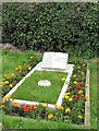
Grave of Winifred Holtby, Rudston churchyard
Winifred Holtby [1898-1935] was born in a nearby farm, lived much of her life in London, but was buried back in her home village. She is best known for her novel 'South Riding', published posthumously in 1936 thanks to editing done by Vera Brittain. The book was made into a three part drama for BBC1 in 2011. Her early death was due to Bright's disease.
Image: © Gordon Hatton
Taken: 10 Sep 2017
0.03 miles
10
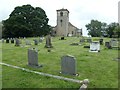
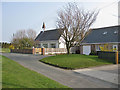
All Saints churchyard, Rudston
From the western edge of the churchyard.
Image: © Christine Johnstone
Taken: 8 Jul 2020
0.03 miles