IMAGES TAKEN NEAR TO
Nafferton, DRIFFIELD, YO25 4LE
Introduction
This page details the photographs taken nearby to YO25 4LE by members of the Geograph project.
The Geograph project started in 2005 with the aim of publishing, organising and preserving representative images for every square kilometre of Great Britain, Ireland and the Isle of Man.

There are currently over 7.5m images from over14,400 individuals and you can help contribute to the project by visiting https://www.geograph.org.uk
Image Map
Images are licensed for reuse under creativecommons.org/licenses/by-sa/2.0
Notes
- Clicking on the map will re-center to the selected point.
- The higher the marker number, the further away the image location is from the centre of the postcode.
Image Listing (4 Images Found)
Images are licensed for reuse under creativecommons.org/licenses/by-sa/2.0
Image
Details
Distance
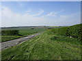
1
Wold Road - Nafferton
Track to Nafferton Kesters, off Wold Road.
Image: © Matthew Blurton
Taken: 30 Jan 2008
0.00 miles
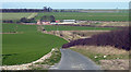
2
Access road down to Nafferton Kesters
It becomes a green dotted grass track when it passes the farm
Image: © Martin Dawes
Taken: 3 Apr 2023
0.07 miles
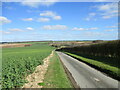
3
Green dotted track toward Nafferton Kesters
Beyond the shelter belt of trees on the left is Nafferton Kesters a mid to late c18 farmhouse
Image: © Martin Dawes
Taken: 3 Apr 2023
0.08 miles