IMAGES TAKEN NEAR TO
Front Street, DRIFFIELD, YO25 3TF
Introduction
This page details the photographs taken nearby to Front Street, YO25 3TF by members of the Geograph project.
The Geograph project started in 2005 with the aim of publishing, organising and preserving representative images for every square kilometre of Great Britain, Ireland and the Isle of Man.

There are currently over 7.5m images from over14,400 individuals and you can help contribute to the project by visiting https://www.geograph.org.uk
Image Map (Loading...)


Getting Data...Please wait
Leaflet Map data © OpenStreetMap
Images are licensed for reuse under creativecommons.org/licenses/by-sa/2.0
Notes
- Clicking on the map will re-center to the selected point.
- The higher the marker number, the further away the image location is from the centre of the postcode.
Image Listing (110 Images Found)
Images are licensed for reuse under creativecommons.org/licenses/by-sa/2.0
Image
Details
Distance
1
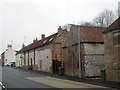
Chalk buildings, Front Street, Langtoft
Chalk is generally softer and less durable than limestone. Thus its use as a building stone (usually known as clunch) is more restricted. Some villages in the Yorkshire Wolds do, however, have substantial numbers of buildings where chalk has been used. Langtoft is one of them.
Image: © Jonathan Thacker
Taken: 24 Mar 2016
0.02 miles
2
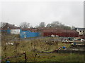
Abandoned building site
Several houses were to be built here but after foundations were laid the work was abandoned.
Image: © Jonathan Thacker
Taken: 24 Mar 2016
0.03 miles
5
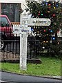
Direction Sign ? Signpost on the B1249 Front Street in Langtoft
Located next to the war memorial on the southwest side of the junction of the B1249 Front Street and Sledmere Road in Langtoft parish. 3 arms but no finial.
Milestone Society National ID: YE_TA0066
Image: © A Wagstaff-Weston
Taken: 26 Dec 2018
0.04 miles
6
Direction Sign ? Signpost on the B1249 Front Street in Langtoft
Located next to the war memorial on the southwest side of the junction of the B1249 Front Street and Sledmere Road in Langtoft parish. 3 arms but no finial. See also https://www.geograph.org.uk/photo/6543487.
Milestone Society National ID: YE_TA0066
Image: © D Phillips
Taken: Unknown
0.04 miles
7
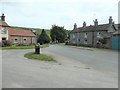
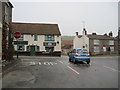
Back Street bus stop, Langtoft
It looks as if the buses might turn round here.
Image: © Christine Johnstone
Taken: 8 Jul 2020
0.04 miles
8
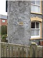
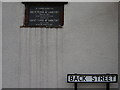
Flood mark on house in Back Street
Langtoft sits at the point where three narrow valleys come together. It has been devastated by floods on several occasions. This plaque marks the level reached on 3rd July 1892 when the water was recorded as seven and a half feet deep.
Image: © Jonathan Thacker
Taken: 24 Mar 2016
0.04 miles
10
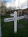
Junction of Sledmere Road and Scarborough Road
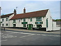
Scarborough road is the main north/south road through the village, Ship Inn across the road
Image: © Martin Dawes
Taken: 8 Nov 2011
0.04 miles