IMAGES TAKEN NEAR TO
Elm Grove, WHITBY, YO22 4RB
Introduction
This page details the photographs taken nearby to Elm Grove, YO22 4RB by members of the Geograph project.
The Geograph project started in 2005 with the aim of publishing, organising and preserving representative images for every square kilometre of Great Britain, Ireland and the Isle of Man.

There are currently over 7.5m images from over14,400 individuals and you can help contribute to the project by visiting https://www.geograph.org.uk
Image Map
Images are licensed for reuse under creativecommons.org/licenses/by-sa/2.0
Notes
- Clicking on the map will re-center to the selected point.
- The higher the marker number, the further away the image location is from the centre of the postcode.
Image Listing (225 Images Found)
Images are licensed for reuse under creativecommons.org/licenses/by-sa/2.0
Image
Details
Distance
1
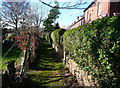
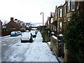
Elm Grove Footpath
A sign states that it is private, but it has a street lamp so I suspect that it is an unadopted street. The land to the left is the disused railway, now used as gardens.
Image: © Humphrey Bolton
Taken: 4 Feb 2014
0.02 miles
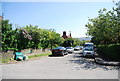
2
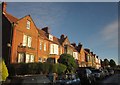
Terrace, Mount Pleasant North, Robin Hood's Bay
One of the Victorian roads that grew up near the station, now used by the Cleveland Way.
Image: © Derek Harper
Taken: 1 Jan 2013
0.03 miles
3
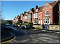
Mount Pleasant North, Robin Hoods Bay
Image: © Humphrey Bolton
Taken: 4 Feb 2014
0.03 miles

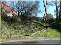
7
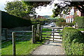
On the path at last
After the climb from Robin Hood's Bay, the coastal path goes along a suburban street, Mount Pleasant North, before reaching this gate. Looking back it is pleasant, for an urban area, but the coastal path awaits.
Image: © Graham Horn
Taken: 18 Sep 2011
0.04 miles
8

Mount Pleasant North, Robin Hood's Bay
The road, little more than a track, veers left to meet the course of the old railway line to Whitby, thus providing access to the Cinder Track walk along the line. Taken from the point where the Cleveland Way leaves onto the coast path (right of camera).
Image: © Derek Harper
Taken: 1 Jan 2013
0.04 miles
10
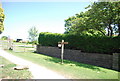
Fingerpost for the Cleveland Way, Mount Pleasant
Image: © N Chadwick
Taken: 4 Jun 2010
0.05 miles