IMAGES TAKEN NEAR TO
Mulgrave Road, WHITBY, YO21 3JL
Introduction
This page details the photographs taken nearby to Mulgrave Road, YO21 3JL by members of the Geograph project.
The Geograph project started in 2005 with the aim of publishing, organising and preserving representative images for every square kilometre of Great Britain, Ireland and the Isle of Man.

There are currently over 7.5m images from over14,400 individuals and you can help contribute to the project by visiting https://www.geograph.org.uk
Image Map
Images are licensed for reuse under creativecommons.org/licenses/by-sa/2.0
Notes
- Clicking on the map will re-center to the selected point.
- The higher the marker number, the further away the image location is from the centre of the postcode.
Image Listing (95 Images Found)
Images are licensed for reuse under creativecommons.org/licenses/by-sa/2.0
Image
Details
Distance
1
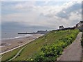
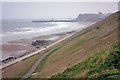
Coastal Path Whitby
Looking East along the coastal path towards Whitby . July 2013
Image: © DTwigg
Taken: 26 Jul 2013
0.04 miles
2
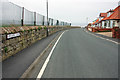
Upgang Lane, Whitby
Follow the lane for access to Upgang Beach. The fence is a protection against errant golf balls.
Image: © Peter Church
Taken: 17 Apr 2009
0.04 miles
3
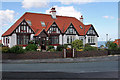
A corner house in Whitby
This house stands on the junction of Love Lane and Upgang Lane, the house faces south.
Image: © Peter Church
Taken: 2 Aug 2008
0.05 miles
4
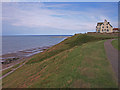
West Cliff, Whitby
Whitby Sands on the left and the pier.
Image: © wfmillar
Taken: 4 Aug 2010
0.06 miles
5
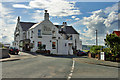
The White House Hotel, Whitby
With Fair Trade and / or vegan catering capabilities this hotel is attractive to the ethical consumer, and also has wonderful views, e.g. Image See http://www.whitehouse-whitby.co.uk/ for more information.
Image: © Peter Church
Taken: 2 Aug 2008
0.06 miles
6
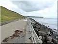
Sea defences at Whitby Sands
The new sea defences and cliff stabilisation works were completed in 1990. Sandsend Ness in the distance.
Image: © Oliver Dixon
Taken: 17 Jun 2018
0.08 miles
7
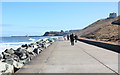
The Cleveland Way approaches Whitby
The path is protected by much granite on the beach. The views towards the breakwater and Whitby Town are excellent on a clear day.
Image: © Peter Church
Taken: 6 Apr 2013
0.08 miles
8
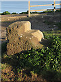
Cut bench mark in old mounting block
At the bottom of Mulgrave Road/Upgang Lane. The Cleveland Way passes beyond the fence.
Image: © Pauline E
Taken: 16 Jan 2012
0.08 miles
9
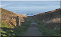
Steps down the cliffside
From Mulgrave Road, there is access to the beach.
Image: © Pauline E
Taken: 16 Jan 2012
0.08 miles
10
West Cliff towards Whitby
Having made the ascent (walking from Sandsend to Whitby) to gain access to Image, one also gets excellent views of the cliff face, and the piers of Whitby Harbour. Also, the distant clifftop is graced by Whitby Abbey.
Image: © Peter Church
Taken: 17 Apr 2009
0.08 miles