IMAGES TAKEN NEAR TO
Mount Close, YORK, YO19 6TH
Introduction
This page details the photographs taken nearby to Mount Close, YO19 6TH by members of the Geograph project.
The Geograph project started in 2005 with the aim of publishing, organising and preserving representative images for every square kilometre of Great Britain, Ireland and the Isle of Man.

There are currently over 7.5m images from over14,400 individuals and you can help contribute to the project by visiting https://www.geograph.org.uk
Image Map
Images are licensed for reuse under creativecommons.org/licenses/by-sa/2.0
Notes
- Clicking on the map will re-center to the selected point.
- The higher the marker number, the further away the image location is from the centre of the postcode.
Image Listing (31 Images Found)
Images are licensed for reuse under creativecommons.org/licenses/by-sa/2.0
Image
Details
Distance

2

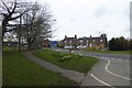
The Selby to York cycle path enters Riccall
The Selby to York cycle path follows the level, straight course of the former course of the East Coast Main Line railway. (This railway line was diverted westwards south of Selby in 1983 to avoid disruption from coal mining.) The cycle path is constructed to a high standard, and is much used by enthusiasts, commuters and leisure cyclists alike. It forms part of National Cycle Network, route 65 and is a spur on the Trans-Pennine Trail.
To the south of Riccall, the path runs adjacent to the A19; through the village the route follows the roads. North of Riccall, the line cuts across country.
Image: © Oliver Dixon
Taken: 21 May 2011
0.04 miles

4
Edge of Riccall
The end of the village on the western side of the A19.
Image: © DS Pugh
Taken: 8 Apr 2018
0.05 miles


8
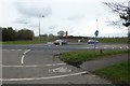
Main Street meets the A19
Main Street Riccall meets the A19. At one stage the A19 ran through the village, but was bypassed when the railway was relocated. A small part of the village lies the other side of the A19. The York to Selby cycle path can be seen in the foreground which heads along the side of the A19 towards Barlby from here.
Image: © DS Pugh
Taken: 8 Apr 2018
0.07 miles
9

Riccall water tower from across the A19
Photo taken from King Rudding Lane. This year's heavy snow has gone from the village but lingers on in the ruts of the ploughed fields. No matter what angle it is viewed from Riccall water tower (in the distance) always looks alien.
Image: © Mick Heraty
Taken: 8 Jan 2009
0.07 miles
10
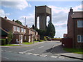
Riccall Water Tower
Would you buy a house next to this monstrosity?
Image: © Sam Kelly
Taken: 9 Aug 2007
0.08 miles