IMAGES TAKEN NEAR TO
Thornton-le-Dale, PICKERING, YO18 7RX
Introduction
This page details the photographs taken nearby to YO18 7RX by members of the Geograph project.
The Geograph project started in 2005 with the aim of publishing, organising and preserving representative images for every square kilometre of Great Britain, Ireland and the Isle of Man.

There are currently over 7.5m images from over14,400 individuals and you can help contribute to the project by visiting https://www.geograph.org.uk
Image Map
Images are licensed for reuse under creativecommons.org/licenses/by-sa/2.0
Notes
- Clicking on the map will re-center to the selected point.
- The higher the marker number, the further away the image location is from the centre of the postcode.
Image Listing (290 Images Found)
Images are licensed for reuse under creativecommons.org/licenses/by-sa/2.0
Image
Details
Distance
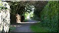
1

Footpath
The photograph shows the northern end of a public footpath that connects Image (ahead, at the gate) with Image (behind the viewpoint).
The property over the wall on the right is ‘Chinagarth’ and over the fence on the left is ‘Old House’ (both private).
For a photograph taken from the same viewpoint but looking in the opposite (southerly) direction, click here Image
Image: © Alan Walker
Taken: 1 May 2007
0.01 miles
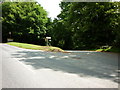
2
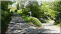
Ellerburn Road
This east north-easterly facing photograph shows Ellerburn Road at a point where a public Image (note the white gate) from Image joins the road.
Behind the viewpoint Ellerburn Road continues south-westerly toward its junction with Whitby Gate.
For a more north-easterly (some 30 metres ahead) photograph of Ellerburn Road, click here Image
Image: © Alan Walker
Taken: 1 May 2007
0.05 miles
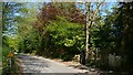
4
Footpath
The southerly facing photograph is of a public footpath (this section is private road) that connects Image (behind the viewpoint) with Image (ahead).
The driveway to the left is to ‘Chinagarth’ and there is a similar one to the right for ‘Old House’ (both private properties).
For a photograph taken from the same viewpoint but looking in the opposite (northerly) direction, click here Image
For a more southerly (ahead) photograph of the footpath, click here Image
Image: © Alan Walker
Taken: 1 May 2007
0.06 miles
5

Thornton Dale Bowling Club
Thornton Dale Bowling Club is situated at the northern end of Priestman’s Lane, near Image
Image: © Alan Walker
Taken: 1 May 2007
0.08 miles
6
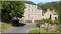
Thornton Mill and Mill House
Ahead, in this north-easterly facing photograph, Priestman’s Lane turns through some 90° clockwise to head south-easterly for a short distance before another turn brings it southerly toward its junction with the footpath, Image
On the cusp of the turn is Thornton Mill with Mill house just to the right of it.
The entrance on the near right is to the Image
A few metres behind the viewpoint the lane ends at it junction with Image
For a more easterly (ahead) photograph of the lane, click here Image
Image: © Alan Walker
Taken: 1 May 2007
0.09 miles
7
Ford Sign, Thornton-le-Dale, Yorkshire
The sign remains, including the "try your brakes" sign on the other side. The ford is, however, long gone, having been replaced by a bridge.
Image: © Christine Matthews
Taken: 5 Aug 2015
0.09 miles
8

Thatched Cottage, Thornton-le-Dale
A most photogenic thatched cottage, used on jigsaw puzzles.
Image: © Bruce McDowall
Taken: 10 Jul 2003
0.09 miles
9
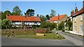
Brook Lane
Brook Lane (in the foreground) is ‘┐shaped’ with the ‘long, horizontal arm’ connecting to Image and the ‘short, vertical arm’ connecting to Image
This north north-easterly photograph is looking across the ‘corner of the two arms’ toward a group of cottages Image
The roadway in front of the houses is public but becomes private after a short distance. However both sections carry a public footpath that connects this viewpoint with Image (ahead).
Behind the viewpoint Image continues toward Chestnut Avenue.
Image: © Alan Walker
Taken: 1 May 2007
0.09 miles
10
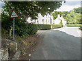
Ellerburn Road
The north-easterly facing photograph shows Ellerburn Road (in the foreground and bearing left) at it junction with the northern end of Priestman’s Lane.
Ahead on Priestman’s Lane (out of shot, just beyond the turn) are Image
Behind the viewpoint Ellerburn Road continues south-westerly toward its junction with Whitby Gate.
For a more south-westerly (some 30metres behind the viewpoint) photograph of Ellerburn Road, click here Image
Image: © Alan Walker
Taken: 1 May 2007
0.10 miles