IMAGES TAKEN NEAR TO
South Lane, PICKERING, YO18 7QU
Introduction
This page details the photographs taken nearby to South Lane, YO18 7QU by members of the Geograph project.
The Geograph project started in 2005 with the aim of publishing, organising and preserving representative images for every square kilometre of Great Britain, Ireland and the Isle of Man.

There are currently over 7.5m images from over14,400 individuals and you can help contribute to the project by visiting https://www.geograph.org.uk
Image Map
Images are licensed for reuse under creativecommons.org/licenses/by-sa/2.0
Notes
- Clicking on the map will re-center to the selected point.
- The higher the marker number, the further away the image location is from the centre of the postcode.
Image Listing (171 Images Found)
Images are licensed for reuse under creativecommons.org/licenses/by-sa/2.0
Image
Details
Distance
1
High Street (A170)
This photograph is looking east north-easterly, ‘up’ High Street (A170) and was taken from the junction with Image (behind the viewpoint, right).
Note the raised pavement on the northern side of the street. This begins at All Saints http://www.freewebs.com/thorntondale/thorntondale.htm church (behind the viewpoint) and extends beyond the curve in the street, ahead.
Behind the viewpoint, on the left, is where the southern end of a short public Image from Image joins the street.
For a more easterly (ahead) photograph of High Street, click here Image
For a more westerly (behind the viewpoint) photograph of the footpath, click here Image
See also this more easterly photograph of High Street by Lis Burke Image
Image: © Alan Walker
Taken: 1 May 2007
0.04 miles
2
High Street, Thornton-le-Dale, Yorkshire
The sign Image] for Appletree Farm can be seen in the wall on the left of the image.
Image: © Christine Matthews
Taken: 3 Jul 2014
0.05 miles
3
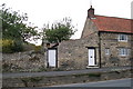
Appletree Farm, Thornton-le-Dale
Set in to the wall between the white gates a carved stone suggests this farm dates from 1634.
Image: © David Rogers
Taken: 7 Oct 2009
0.05 miles
4
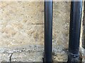
Thornton le Dale, The Grange
The benchmark is cut into a right cornerstone of the property on the south side of the Main Street.
Image: © Mel Towler
Taken: 12 Apr 2022
0.05 miles
5
Thornton le Dale, The Grange
There is a benchmark cut into a right cornerstone of the property on the south side of the Main Street.
Image: © Mel Towler
Taken: 12 Apr 2022
0.05 miles
6
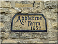
House Sign, Appletree Farm 1635, High Street, Thornton-le-Dale, Yorkshire
No longer a farm, but the sign remains.
Image: © Christine Matthews
Taken: 3 Jul 2014
0.06 miles
7
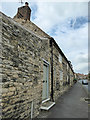
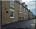
Terraced cottages
East of the church in Thornton le Dale, these terraced stone cottages line the main road as it drops into the village.
Image: © Lis Burke
Taken: 18 Oct 2005
0.06 miles
8
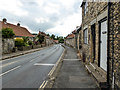
High Street, Thornton-le-Dale, Yorkshire
Looking along the High Street towards the church.
Image: © Christine Matthews
Taken: 3 Jul 2014
0.06 miles
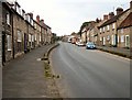
9
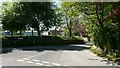
South Lane
The photograph shows the eastern end of South Lane and was taken from its junction with Image (immediate left foreground).
South Lane runs to the south of, and parallel to High Street (A170), the main road into the village from the east.
For a photograph of the western (ahead) end of South Lane, click here Image
Some 30metres to the right is this view of Images junction with High Street.
Image: © Alan Walker
Taken: 1 May 2007
0.07 miles
10
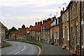
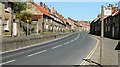
Terraced Cottages
Looking down High Street on the A170 towards the centre of Thornton le Dale.
Image: © David Rogers
Taken: 2 Jul 2008
0.07 miles