IMAGES TAKEN NEAR TO
Settrington, MALTON, YO17 8NT
Introduction
This page details the photographs taken nearby to YO17 8NT by members of the Geograph project.
The Geograph project started in 2005 with the aim of publishing, organising and preserving representative images for every square kilometre of Great Britain, Ireland and the Isle of Man.

There are currently over 7.5m images from over14,400 individuals and you can help contribute to the project by visiting https://www.geograph.org.uk
Image Map
Images are licensed for reuse under creativecommons.org/licenses/by-sa/2.0
Notes
- Clicking on the map will re-center to the selected point.
- The higher the marker number, the further away the image location is from the centre of the postcode.
Image Listing (14 Images Found)
Images are licensed for reuse under creativecommons.org/licenses/by-sa/2.0
Image
Details
Distance
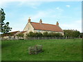
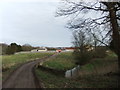
2
Kirk Hill
View of Kirk Hill, surrounded by mist, from the track leading towards Settrington.
Image: © Dr Patty McAlpin
Taken: 27 Jun 2009
0.02 miles
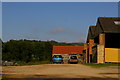
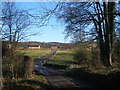
7
Access road from Kirk Hill over Settrington Beck
This road comes out on Back Lane near the Station House
Image: © Martin Dawes
Taken: 9 Jul 2014
0.09 miles
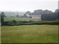
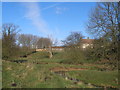
8
Bridge over Settrington Beck towards Kirk Hill Farm
Image: © John Slater
Taken: 9 Feb 2013
0.10 miles
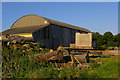
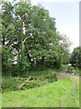
10
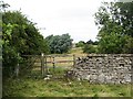
Centenary Way approaching Kirk Hill
The footpath keeps close to the banks of Settrington Beck for some way here, but the line is often hidden by long grass, suggesting that the Centenary Way does not see that many users. Kirk Hill farm is just visible, old OS maps suggest the site of an early church nearby - thus the name. Note that the wall appears to be made of a jurassic limestone, despite the fact that the area is just below the western edge of the chalk Wolds.
Image: © Gordon Hatton
Taken: 7 Aug 2016
0.15 miles