IMAGES TAKEN NEAR TO
Sheepfoot Hill, MALTON, YO17 7DU
Introduction
This page details the photographs taken nearby to Sheepfoot Hill, YO17 7DU by members of the Geograph project.
The Geograph project started in 2005 with the aim of publishing, organising and preserving representative images for every square kilometre of Great Britain, Ireland and the Isle of Man.

There are currently over 7.5m images from over14,400 individuals and you can help contribute to the project by visiting https://www.geograph.org.uk
Image Map
Images are licensed for reuse under creativecommons.org/licenses/by-sa/2.0
Notes
- Clicking on the map will re-center to the selected point.
- The higher the marker number, the further away the image location is from the centre of the postcode.
Image Listing (186 Images Found)
Images are licensed for reuse under creativecommons.org/licenses/by-sa/2.0
Image
Details
Distance
1
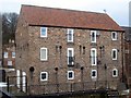
Former warehouse, Castlegate
A grade II listed former warehouse, dated early C19. Constructed in pink and cream mottled brick on a chamfered sandstone plinth, and with a pantile roof.
LBS No: 389407
Image: © Mike Kirby
Taken: 13 Feb 2012
0.00 miles
2
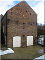
Former riverside warehouse, Castlegate
Side view of the warehouse. See Image
Image: © Mike Kirby
Taken: 13 Feb 2012
0.00 miles
3
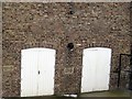
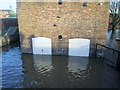
Former riverside warehouse, flood lines
In 2000 the rain really came down on Malton, causing flooding yet again as in 1999. Most of the land bordering the R.Derwent was flooded and the town came to a standstill. The river spilled over onto the railway, stopping all rail traffic for several days. Seeing the 2000 floodline on the left of the building shows how high the river rose above normal levels.
See Image
Image: © Mike Kirby
Taken: 13 Feb 2012
0.00 miles
4
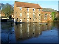
River Derwent in flood at Malton 27th Dec 2015 (10)
Riverside warehouse once more meets the floodwater. On the end of the building by the large white doors are marked the levels of previous floodwater. The bridge is closed to traffic
Image: © Martin Dawes
Taken: 27 Dec 2015
0.00 miles
5
River Derwent in flood at Malton 27th Dec 2015 (11)
The flood defence wall is to the left of the warehouse!! To the left of the white doors is a Flood Level mark for November 2000, in between the doors is the mark for March 1999, two other marks are to the right,older and obscured by the fencing.
Image: © Martin Dawes
Taken: 27 Dec 2015
0.00 miles
6
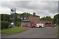
Malton Fire Station
Just North of the bridge over the Derwent.
Image: © Colin Grice
Taken: 28 May 2006
0.01 miles
7
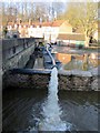
River Derwent in flood at Malton 27th Dec 2015 (13)
Pumping floodwater back into the river over the flood defence wall. A pipe goes into a manhole by the yellow pump. Bridge closed to traffic
Image: © Martin Dawes
Taken: 27 Dec 2015
0.02 miles
8
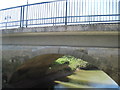
Bridge over River Derwent
Between Malton and Norton, now with a modern footbridge to the side, this partially blocks out the bridge in this photo.
Image: © Martin Dawes
Taken: 15 Apr 2014
0.02 miles
10
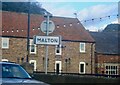
Malton sign on County Bridge
The County Bridge crosses the River Derwent, the historic boundary of the North and East Ridings of Yorkshire
Image: © Lauren
Taken: 22 Oct 2008
0.03 miles