IMAGES TAKEN NEAR TO
Bempton Lane, BRIDLINGTON, YO15 1PP
Introduction
This page details the photographs taken nearby to Bempton Lane, YO15 1PP by members of the Geograph project.
The Geograph project started in 2005 with the aim of publishing, organising and preserving representative images for every square kilometre of Great Britain, Ireland and the Isle of Man.

There are currently over 7.5m images from over14,400 individuals and you can help contribute to the project by visiting https://www.geograph.org.uk
Image Map (Loading...)


Getting Data...Please wait
Leaflet Map data © OpenStreetMap
Images are licensed for reuse under creativecommons.org/licenses/by-sa/2.0
Notes
- Clicking on the map will re-center to the selected point.
- The higher the marker number, the further away the image location is from the centre of the postcode.
Image Listing (400 Images Found)
Images are licensed for reuse under creativecommons.org/licenses/by-sa/2.0
Image
Details
Distance
1

Bungalow on Castle Crescent, Flamborough
Flamborough Scarecrow Festival, 2012.
Image: © JThomas
Taken: 20 Aug 2012
0.02 miles
2

Seabirds Restaurant and Bar, Tower Street, Flamborough
Image: © Humphrey Bolton
Taken: 26 Dec 2010
0.07 miles
3
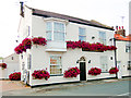
Pretty in Pink, Seabirds Inn, Flamborough
Local restaurant
Image: © Scott Robinson
Taken: 21 May 2014
0.07 miles
4
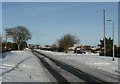
Bempton Road, Flamborough
At the junction with Carter Lane.
Image: © Humphrey Bolton
Taken: 26 Dec 2010
0.08 miles
5

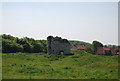
Flamborough Castle
The photograph shows the tower, being the only remains above ground, and associated earthworks.
This 'castle' was, in fact, the fortified manor house of the Constable family who had received licence to crenelate in 1351. Although containing a tower, a hall, a great parlour, a lord’s parlour, a chapel, a court house, a mill house, and a great barn it was described in the early 16th century as being taken for a manor house rather than a castle. It can be compared with the Northumbrian ‘Pele’ towers and, like them, was probably made defensible to guard against Scottish raiders.
The above paragraph was adapted from an East Riding Council leaflet that is available online: http://www.eastriding.gov.uk/EasySiteWeb/GatewayLink.aspx?alId=2256 .
Click here for another photograph of the castle: http://www.geograph.org.uk/photo/1772032 .
For a photograph showing the tower, click here: http://www.geograph.org.uk/photo/1772013 .
- - -
For other photographs of the castle see the following by:
Paul Allison: Image,
Paul Glazzard: Image and
J Thomas: Image
Image: © Alan Walker
Taken: 14 Mar 2010
0.08 miles
6
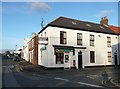
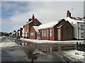
Flamborough post office
For sale at present. It is appropriately in Post Office Street.
Image: © Humphrey Bolton
Taken: 6 Nov 2010
0.08 miles
7

The fishermen's monument, Flamborough
See Image for the plaque facing the camera; there are also plaques on the other three sides.
Image: © Humphrey Bolton
Taken: 6 Nov 2010
0.08 miles
8
The Methodist Chapel, Flamborough
This replaced two former 19C chapels the village. It is on the site of the Primitive Methodist Chapel, which was built in 1874 on the site of the first chapel of 1821 and two cottages. The Wesleyan Chapel was in a large plot that is now the Chapel Close housing estate. It was built in 1889, replacing an earlier chapel on the site of the garage on the other side of Chapel Street. By 1971 the congregation had dwindled and the chapel had to close. This information is from Frank Brearley's 'History of Flamborough', which contains extracts from the records of the Primitive Methodist Chapel.
Image: © Humphrey Bolton
Taken: 24 Dec 2010
0.08 miles
9
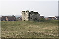
Flamborough Castle
The scant remains of a medieval fortified manor house. Stands in the middle of a field.
Image: © JThomas
Taken: 20 Mar 2009
0.08 miles