IMAGES TAKEN NEAR TO
Wheelhouse Square, SCARBOROUGH, YO12 7SP
Introduction
This page details the photographs taken nearby to Wheelhouse Square, YO12 7SP by members of the Geograph project.
The Geograph project started in 2005 with the aim of publishing, organising and preserving representative images for every square kilometre of Great Britain, Ireland and the Isle of Man.

There are currently over 7.5m images from over14,400 individuals and you can help contribute to the project by visiting https://www.geograph.org.uk
Image Map
Images are licensed for reuse under creativecommons.org/licenses/by-sa/2.0
Notes
- Clicking on the map will re-center to the selected point.
- The higher the marker number, the further away the image location is from the centre of the postcode.
Image Listing (331 Images Found)
Images are licensed for reuse under creativecommons.org/licenses/by-sa/2.0
Image
Details
Distance
1

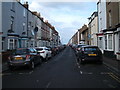
Wrea Lane
This is Wrea Lane from the junction with Lower Durham Street. These 19th century industrial buildings survived the clearance of the William Street/Hope Street and lower Durham Street area referred to in Image although much altered and still have an active use.
Image: © Christopher Hall
Taken: 10 Apr 2014
0.00 miles
2

Wheelhouse Square off Dean Road
Looking into Wheelhouse Square from Dean Road. Almshouses were first built here in 1865, about opposite the workhouse, designed by William Baldwin Stewart who designed the nearby gaol. Those were replaced by the current social housing in 1968 by the Wheelhouse Square Trust.
Image: © Christopher Hall
Taken: 10 Dec 2013
0.01 miles
3
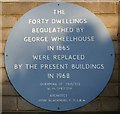
Plaque in Wheelhouse Square
Details of a blue plaque in Wheelhouse Square marking the rebuilding in 1968.
Image: © Christopher Hall
Taken: 10 Dec 2013
0.02 miles
4
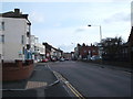
Trafalgar Road, Scarborough
Looking north from Dean Road.
Image: © JThomas
Taken: 13 Feb 2016
0.04 miles
6
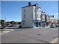
KAY'S CAF? on Dean Road
Looking across Dean Road towards KAY'S CAFÉ at the junction with Wrea Lane.
Image: © John S Turner
Taken: 9 Jul 2010
0.04 miles
8
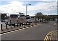
William Street coach park from Lower Durham Street
Another view of William street coach park also shown in Image
Image: © Christopher Hall
Taken: 10 Apr 2014
0.04 miles
9
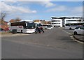
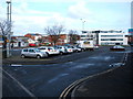
William Street coach park
William Street coach park is on the site of William street and the greater part of Hope Street which cleared as part of the general improvement area provisions. The new building in the right background is The Street. In the left background can be seen industrial units on the former Lower Durham Street which was also cleared.
Image: © Christopher Hall
Taken: 10 Apr 2014
0.05 miles
10

Blue plaque on the former model workhouse, Dean Road
Details of a blue Heritage Trail plaque above the entrance to the former model workhouse
Image: © Christopher Hall
Taken: 10 Dec 2013
0.05 miles