IMAGES TAKEN NEAR TO
Durham Street, SCARBOROUGH, YO12 7PT
Introduction
This page details the photographs taken nearby to Durham Street, YO12 7PT by members of the Geograph project.
The Geograph project started in 2005 with the aim of publishing, organising and preserving representative images for every square kilometre of Great Britain, Ireland and the Isle of Man.

There are currently over 7.5m images from over14,400 individuals and you can help contribute to the project by visiting https://www.geograph.org.uk
Image Map
Images are licensed for reuse under creativecommons.org/licenses/by-sa/2.0
Notes
- Clicking on the map will re-center to the selected point.
- The higher the marker number, the further away the image location is from the centre of the postcode.
Image Listing (403 Images Found)
Images are licensed for reuse under creativecommons.org/licenses/by-sa/2.0
Image
Details
Distance
1
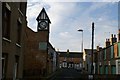
Durham Place
Durham Place is a narrow street which runs off North Marine Road, but it widens out to create a little square. This street was developed in the 1860s largely as mews, stables, carriage houses, hay lofts and small servants' dwellings to serve the needs of the well-to-do residents and visitors in North Marine Road. the former stables and haylofts on the right are now garages. The building with the clock was once industrial use but has now been converted to residences. Crossing the end of Durham Place are houses on Howard Street built 1880-1883.
Image: © Christopher Hall
Taken: 10 Dec 2013
0.03 miles
2
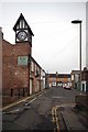
Durham Place Scarborough
Mews houses and workshops in a Scarborough back street. N.B the clock was telling the correct time (A.M)
Image: © Glyn Baker
Taken: 27 Apr 2014
0.04 miles
3
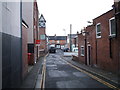
Durham Place, Scarborough
Off North Marine Road.
Image: © JThomas
Taken: 13 Feb 2016
0.04 miles
4
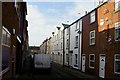
Clark Street
Looking down Clark Street which is a street of tightly built working class houses of about 1850-1860. The building on the right is The Free Dwellings built 1852 (but still 'Georgian' in style) and renovated in 1978. Lower Clark Street terminates at the bottom of the street with social housing built in 1986.
Image: © Christopher Hall
Taken: 10 Dec 2013
0.05 miles
5
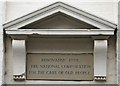
Plaque on the Free Dwellings 5-6 Clark Street
Details of a plaque marking the renovation of the Free Dwellings in 1978.
Image: © Christopher Hall
Taken: 10 Dec 2013
0.05 miles
6
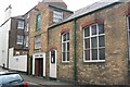
Gospel Hall
Durham Street Gospel Hall, Scarborough
Image: © Darren Haddock
Taken: 15 Jul 2005
0.05 miles
7
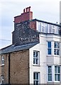
Scarborough : Trafalgar Square ghost sign
Image: © Jim Osley
Taken: 14 Mar 2020
0.06 miles
8
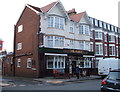
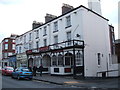
The Abert public house, Scarborough
On North Marine Road.
Image: © JThomas
Taken: 13 Feb 2016
0.06 miles
9
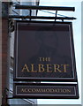
Sign for the Abert public house, Scarborough
Image: © JThomas
Taken: 13 Feb 2016
0.06 miles
10
The Durham Hotel, Scarborough
On North Marine Road.
Image: © JThomas
Taken: 13 Feb 2016
0.07 miles