IMAGES TAKEN NEAR TO
Northway, SCARBOROUGH, YO12 7AF
Introduction
This page details the photographs taken nearby to Northway, YO12 7AF by members of the Geograph project.
The Geograph project started in 2005 with the aim of publishing, organising and preserving representative images for every square kilometre of Great Britain, Ireland and the Isle of Man.

There are currently over 7.5m images from over14,400 individuals and you can help contribute to the project by visiting https://www.geograph.org.uk
Image Map (Loading...)


Getting Data...Please wait
Leaflet Map data © OpenStreetMap
Images are licensed for reuse under creativecommons.org/licenses/by-sa/2.0
Notes
- Clicking on the map will re-center to the selected point.
- The higher the marker number, the further away the image location is from the centre of the postcode.
Image Listing (415 Images Found)
Images are licensed for reuse under creativecommons.org/licenses/by-sa/2.0
Image
Details
Distance
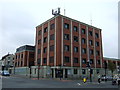
5
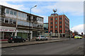
Northway, Scarborough
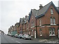
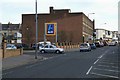
The street called Northway was created in the 1930s in order to improve traffic links from the South cliff area, across Valley Bridge, to the north side. Demolition started in 1930 and at this point Albion Street was removed completely. The large brick building was built by the Ministry of Works in the 1950s. The Aldi sign and car park are on the site of the former West Yorkshire Road Car Company bus station and garage, built in 1939. After going out of use it became a motor dealership but was subsequently demolished to make way for the Aldi car park. The 'shadow' of the bus station building can be seen on the end wall of the 1950s building.
Image: © Christopher Hall
Taken: 10 Jan 2014
0.07 miles

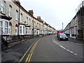
7
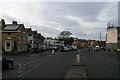
Northway and Barwick Street junction
The street called Northway was created in the 1930s in order to improve traffic links from the South cliff area, across Valley Bridge, to the north side. Demolition started in 1930 and at this point Lower Albion Street was greatly altered by the removal of a large house and garden called Westbrook; houses on the south side of what was Lower Albion Road remain on the spur road beyond the junction with Barwick Street but are now numbered in Northway. This realignment created a triangular green space where the trees are.
Image: © Christopher Hall
Taken: 10 Jan 2014
0.07 miles
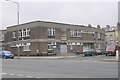
9
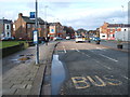
Scarborough Police Station
Next door to the courthouse on Northway.
Image: © Pauline E
Taken: 19 Nov 2013
0.07 miles