IMAGES TAKEN NEAR TO
Salisbury Street, SCARBOROUGH, YO12 4EH
Introduction
This page details the photographs taken nearby to Salisbury Street, YO12 4EH by members of the Geograph project.
The Geograph project started in 2005 with the aim of publishing, organising and preserving representative images for every square kilometre of Great Britain, Ireland and the Isle of Man.

There are currently over 7.5m images from over14,400 individuals and you can help contribute to the project by visiting https://www.geograph.org.uk
Image Map
Images are licensed for reuse under creativecommons.org/licenses/by-sa/2.0
Notes
- Clicking on the map will re-center to the selected point.
- The higher the marker number, the further away the image location is from the centre of the postcode.
Image Listing (95 Images Found)
Images are licensed for reuse under creativecommons.org/licenses/by-sa/2.0
Image
Details
Distance
1
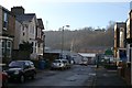
Salisbury Street
Another Street running off from Seamer Road. This street contains a mixture of residential uses.The area beyond the steel fence and gates is the site of Scarborough's first power station.Scarborough Corporation obtained powers in 1891 to supply electricity but in 1894 transferred those powers to the Scarborough Electric Supply Company. Construction of the power station commenced in February 1893 and supply of electricity started in August of that year. From 1904 the Scarborough Tramways Company was supplied. In 1925 Scarborough Corporation re-acquired the undertaking and on 1st April 1948 it was taken over by the British Electricity Authority when electricity undertakings were nationalised. Power now comes in from the national grid and there is nothing to see of the power station, the site is a small industrial estate.
Image: © Christopher Hall
Taken: 20 Jan 2014
0.01 miles
2

Beaconsfield Street, Falsgrave
Looking west from Seamer Road (A64).
Image: © JThomas
Taken: 20 Feb 2016
0.03 miles
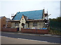
3
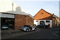
Mount View Avenue/Back Beaconsfield Street junction
The narrow road to the right of the slate roofed building is the rear service lane to terrace houses on Beaconsfield Street. It widens out to become Mount View Avenue which is mostly residential but at this point is commercial in use. The slate roofed building was probably built in the mid 19th century in association with the nearby brickworks, but for many years was a laundry and now motor repairs. the nearer building houses a specialist in the restoration of Austin Healey sports cars.
Image: © Christopher Hall
Taken: 20 Jan 2014
0.04 miles
4
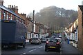
Spring Bank
Spring bank is a street mostly of fairly modest bye-law housing of about 1880 which runs off Seamer Road. there are some 1960s flats at the top end.
The view is terminated by the wooded slopes of Falsgrave Park where the springs are to which the street name refers.
Image: © Christopher Hall
Taken: 20 Jan 2014
0.05 miles
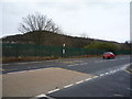
5
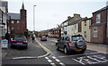
Seamer Road (A64), Falsgrave
Looking north.
Image: © JThomas
Taken: 20 Feb 2016
0.06 miles

7
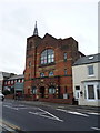
Former Primitive Methodist Church, Falsgrave
Now converted into flats.
Image: © JThomas
Taken: 20 Feb 2016
0.07 miles
10

Spring Bank, Falsgrave
Looking west from Seamer Road (A64).
Image: © JThomas
Taken: 20 Feb 2016
0.08 miles