IMAGES TAKEN NEAR TO
WOLVERHAMPTON, WV99 1GF
Introduction
This page details the photographs taken nearby to WV99 1GF by members of the Geograph project.
The Geograph project started in 2005 with the aim of publishing, organising and preserving representative images for every square kilometre of Great Britain, Ireland and the Isle of Man.

There are currently over 7.5m images from over14,400 individuals and you can help contribute to the project by visiting https://www.geograph.org.uk
Image Map
Images are licensed for reuse under creativecommons.org/licenses/by-sa/2.0
Notes
- Clicking on the map will re-center to the selected point.
- The higher the marker number, the further away the image location is from the centre of the postcode.
Image Listing (16 Images Found)
Images are licensed for reuse under creativecommons.org/licenses/by-sa/2.0
Image
Details
Distance
3
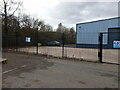
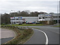
The southern end of industrial units on Stafford Park 4
Part of the extensive Stafford Park industrial estate, which largely occupies an area where the former Stafford Colliery (coal and ironstone) once existed. It was in operation from about 1875 to 1940 under the ownership of the Lilleshall Company, and was mapped as mostly still there in the late 1940s, but presumably had ceased to operate by then, and by the time the Telford Development Corporation came into existence in the 1960s, the land was available for purchase and redevelopment into Stafford Park.
Image: © Richard Law
Taken: 25 Feb 2023
0.20 miles
4
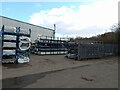
Factory unit and stored parts on Stafford Park 4
Most of the units on this side of the road seem to be the premises of a window & door manufacturer, so these are presumably UPVC profiles and the like, awaiting their turn to be assembled into frames.
Image: © Richard Law
Taken: 25 Feb 2023
0.20 miles
5
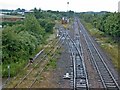
Madeley Junction
The two-track line going straight on carries passengers and freight between Wolverhampton and Shrewsbury. The single track branch turns south towards Madeley and is used solely to supply coal to the Ironbridge Gorge Power station in Image
Image: © Mike White
Taken: 3 Jul 2008
0.21 miles
6
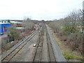
Madeley Junction
The railway line heading off to the left is the former Madeley Branch line of the GWR, which originally connected into the (long-removed) line along the Severn valley between Bridgnorth and Shrewsbury. Until fairly recently, it was used for coal supplies to the Ironbridge power station, but that has now been decommissioned and demolished, the site being earmarked for a large housing development; there are hopes that the railway will be kept in place to provide an alternative means of transport for the residents of that new village. We shall see...
Image: © Richard Law
Taken: 22 Jan 2022
0.21 miles
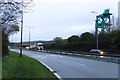
9

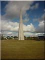
Towards the obelisk at Nairn roundabout
Image: © John Slater
Taken: 11 Sep 2019
0.22 miles
10
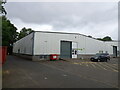
Light industrial units on Stafford Park 4
A typical example of the ready-made units commonplace throughout the industrial estate.
Image: © Richard Law
Taken: 28 Jul 2023
0.23 miles