IMAGES TAKEN NEAR TO
Clewley Drive, WOLVERHAMPTON, WV9 5LA
Introduction
This page details the photographs taken nearby to Clewley Drive, WV9 5LA by members of the Geograph project.
The Geograph project started in 2005 with the aim of publishing, organising and preserving representative images for every square kilometre of Great Britain, Ireland and the Isle of Man.

There are currently over 7.5m images from over14,400 individuals and you can help contribute to the project by visiting https://www.geograph.org.uk
Image Map
Images are licensed for reuse under creativecommons.org/licenses/by-sa/2.0
Notes
- Clicking on the map will re-center to the selected point.
- The higher the marker number, the further away the image location is from the centre of the postcode.
Image Listing (90 Images Found)
Images are licensed for reuse under creativecommons.org/licenses/by-sa/2.0
Image
Details
Distance
1
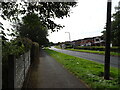
The Droveway
The view at Pendeford, Wolverhampton.
Image: © Gordon Griffiths
Taken: 28 Sep 2020
0.08 miles
2
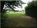
Bowling Club
The view of the Fordhouse club alongside the Staffordshire and Worcestershire Canal near Marsh lane Bridge at Pendeford.
Image: © Gordon Griffiths
Taken: 28 Sep 2020
0.08 miles
3
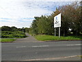
Path from The Droveway
The view at Pendeford.
Image: © Gordon Griffiths
Taken: 28 Sep 2020
0.09 miles
6
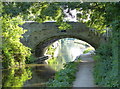
Marsh Lane Bridge (2), Wolverhampton
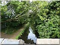
Marsh Lane Bridge is at the southern end of a narrow part of the Staffordshire and Worcestershire Canal. The bridge is also deceptively low on the non-towpath side of the bridge hole. Boat tillermen should always steer near to the towpath when negotiating the bridge. This one, on quite a low boat, ducks safely, but it is from the other direction that mistakes are more often made! :-)
The narrows are cut into the sandstone rock, and for half a mile or so narrowboats cannot pass each other. There are two wider spots in the narrows where one (maybe two) boat(s) can pass another coming the other way. The latest Nicholson Guide mentions that locally the stretch is called "Pendeford Rockin'", after a local farm.
Image: © Roger D Kidd
Taken: 16 Oct 2008
0.11 miles
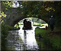
7
Marsh Lane Bridge (3), Wolverhampton
Marsh Lane Bridge is at the southern end of a narrow part of the Staffordshire and Worcestershire Canal. The bridge is also deceptively low on the non-towpath side of the bridge hole. Boat tillermen should always steer near to the towpath when negotiating the bridge. This one, on quite a low boat, has negotiated safely, but it is from the other direction that mistakes are more often made on the entry bend, especially with the many boats which stand higher out of the water! :-)
The narrows are cut into the sandstone rock, and for half a mile or so narrowboats cannot pass each other. There are two wider spots in the narrows where one (maybe two) boat(s) can pass another coming the other way. The latest Nicholson Guide mentions that locally the stretch is called "Pendeford Rockin'", after a local farm.
Image: © Roger D Kidd
Taken: 16 Oct 2008
0.12 miles
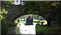
8
Marsh Lane Bridge near Fordhouses in Wolverhampton
This is the Staffordshire and Worcestershire Canal at Marsh Lane Bridge (No 67), looking north-north-east towards the infamous Marsh Lane Narrows, where the canal is cut through the red sandstone bedrock.
Image: © Roger Kidd
Taken: 14 May 2016
0.12 miles
9
Bridge Scene
The view of the Staffordshire and Worcestershire Canal from Marsh lane Bridge at Pendeford.
Image: © Gordon Griffiths
Taken: 28 Sep 2020
0.12 miles
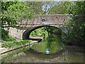
10
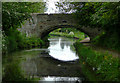
Marsh Lane Bridge at Fordhouses, Wolverhampton
On the Staffordshire and Worcestershire Canal travelling south, this bridge marks the end of the gloomy tree enshrouded "narrows", much of which do not allow boats to pass each other. The bridge carries a public footpath between Marsh Lane (vehicular) and Pendeford Lane (footpath).
Image: © Roger D Kidd
Taken: 19 May 2009
0.12 miles