IMAGES TAKEN NEAR TO
Wobaston Road, WOLVERHAMPTON, WV9 5EU
Introduction
This page details the photographs taken nearby to Wobaston Road, WV9 5EU by members of the Geograph project.
The Geograph project started in 2005 with the aim of publishing, organising and preserving representative images for every square kilometre of Great Britain, Ireland and the Isle of Man.

There are currently over 7.5m images from over14,400 individuals and you can help contribute to the project by visiting https://www.geograph.org.uk
Image Map
Images are licensed for reuse under creativecommons.org/licenses/by-sa/2.0
Notes
- Clicking on the map will re-center to the selected point.
- The higher the marker number, the further away the image location is from the centre of the postcode.
Image Listing (55 Images Found)
Images are licensed for reuse under creativecommons.org/licenses/by-sa/2.0
Image
Details
Distance
1
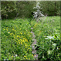
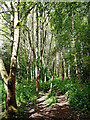
Permissive path near Pendeford in Staffordshire
Looking north-west towards Wobaston Road (three hundred metres), this very pleasant track leads from the Pendeford Public Nature Walk (and The Droveway). The River Penk is close by, off to the left.
Image: © Roger Kidd
Taken: 15 May 2023
0.08 miles
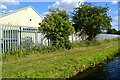
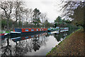
3
Towpath along the Shropshire Union Canal
Image: © Mat Fascione
Taken: 21 Apr 2018
0.11 miles
4
Woodland track to Wobaston Road near Pendeford, Staffordshire
Looking north-north-west.
There is a strip of woodland between the River Penk and fields by Upper Pendeford Farm. A permissive path leads through it, linking The Droveway (and the Pendeford Public Nature Walk) with Wobaston Road (about 480 metres ahead). The track is not signposted, or shown on maps as a public footpath.
Image: © Roger Kidd
Taken: 15 May 2023
0.12 miles
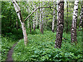
5
Woodland track near Pendeford, Wolverhampton
Looking north-north-west.
There is a strip of woodland between the River Penk and fields by Upper Pendeford Farm. A permissive path leads through it, linking The Droveway (and the Pendeford Public Nature Walk) with Wobaston Road (about 480 metres ahead). The track is not signposted, or shown on maps as a public footpath.
Image: © Roger Kidd
Taken: 15 May 2023
0.12 miles
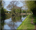
6
Glass-like stillness on the Shropshire Union Canal
The narrowboats are moored along the canal from Wolverhampton Boat Club.
Image: © Bill Boaden
Taken: 10 Nov 2016
0.13 miles
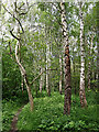
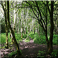
7
Birch woods near Pendeford in Staffordshire
Looking north towards Wobaston Road. Although not marked on maps as a public footpath, it is permitted to use it, linking The Droveway with Wobaston Road.
Image: © Roger Kidd
Taken: 15 May 2023
0.13 miles
8
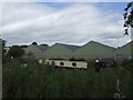
Former Boulton Paul works
Boulton Paul moved to this site in Wolverhampton alongside the Shropshire Union Canal in the interwar period and manufactured the Defiant night fighter and gun turrets. The site is now partly occupied by Smiths Aerospace, one of a cluster of aerospace companies in this area.
Image: © John M
Taken: 4 Aug 2007
0.14 miles
9
Woodland track near Pendeford in Staffordshire
Looking north-north-west.
There is a strip of woodland between the River Penk (off to the let) and fields by Upper Pendeford Farm. A permissive path leads through it, linking The Droveway (and the Pendeford Public Nature Walk) with Wobaston Road (about 480 metres ahead). The track is not signposted, or shown on maps as a public footpath.
Image: © Roger Kidd
Taken: 15 May 2023
0.14 miles
10

Approaching Pendeford Bridge
The Shropshire Union Canal.
Image: © Gordon Griffiths
Taken: 25 Aug 2008
0.14 miles