IMAGES TAKEN NEAR TO
Coatsgate Walk, WOLVERHAMPTON, WV8 1XS
Introduction
This page details the photographs taken nearby to Coatsgate Walk, WV8 1XS by members of the Geograph project.
The Geograph project started in 2005 with the aim of publishing, organising and preserving representative images for every square kilometre of Great Britain, Ireland and the Isle of Man.

There are currently over 7.5m images from over14,400 individuals and you can help contribute to the project by visiting https://www.geograph.org.uk
Image Map
Images are licensed for reuse under creativecommons.org/licenses/by-sa/2.0
Notes
- Clicking on the map will re-center to the selected point.
- The higher the marker number, the further away the image location is from the centre of the postcode.
Image Listing (69 Images Found)
Images are licensed for reuse under creativecommons.org/licenses/by-sa/2.0
Image
Details
Distance
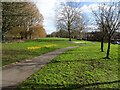
1
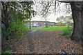
Path to houses on Bridgefoot Walk
A path leading away from the Shropshire Union Canal.
Image: © Bill Boaden
Taken: 10 Nov 2016
0.02 miles
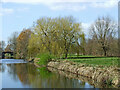
2
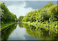
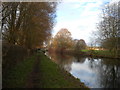
The Shropshire Union Canal near Wolverhampton
Stormy clouds were forming here where the canal cuts through Pendeford and approaches Barnhurst Bridge, No 2.
Note: Nicholson's Canal Guides, and other canal sources refer to this as Bathurst Bridge. As Barnhurst relates to an ancient local family and nearby part of Pendeford, that seems the more likely name for the bridge.
Image: © Roger D Kidd
Taken: 19 May 2009
0.04 miles
3
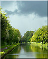
The Shropshire Union Canal near Wolverhampton
Stormy clouds were forming here where the canal approaches Barnhurst Bridge, No 2.
Note: Nicholson's Waterways Guides, and other canal sources refer to this as Bathurst Bridge. As Barnhurst relates to an ancient local family and nearby part of Pendeford, that seems the more likely name for the bridge.
Image: © Roger D Kidd
Taken: 19 May 2009
0.04 miles
4
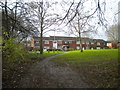
Footpath to Bridgefoot Walk, Ryefield
Seen from the towpath of the Shropshire Union Canal.
Image: © Richard Vince
Taken: 8 Dec 2018
0.05 miles
5
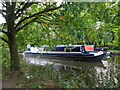
Passing Boat
The view of the Shropshire Union Canal in Wolverhampton.
Image: © Gordon Griffiths
Taken: 28 Sep 2020
0.05 miles
6
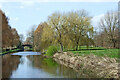
Canal and parkland near Pendeford in Wolverhampton
This is the Shropshire Union Canal, looking north-west towards Barnhust Bridge, No 2.
Image: © Roger Kidd
Taken: 19 Apr 2013
0.05 miles
7
Shropshire Union Canal near Pendeford (1)
Looking towards Nantwich as the canal passes through Wolverhampton's northern suburbs.
Image: © Richard Vince
Taken: 8 Dec 2018
0.06 miles
8
Shropshire Union Canal at Pendeford, Wolverhampton
Ahead is Bridge No 2, Barnhurst Bridge (Bathurst Bridge in Nicholson Guides). Houdsing is in Cornfield, and (far left) Duffield Close.
Image: © Roger D Kidd
Taken: 31 May 2013
0.07 miles
9
Crocuses Path
The view by the Shropshire Union Canal in Pendeford, Wolverhampton.
Image: © Gordon Griffiths
Taken: 25 Feb 2022
0.07 miles
10
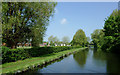
Canalside parkland near Pendeford in Wolverhampton
This shows the Shropshire Union Canal, looking north-west towards Barnhust Bridge, No 2.
Image: © Roger Kidd
Taken: 19 Apr 2013
0.07 miles