IMAGES TAKEN NEAR TO
County Lane, WOLVERHAMPTON, WV8 1RG
Introduction
This page details the photographs taken nearby to County Lane, WV8 1RG by members of the Geograph project.
The Geograph project started in 2005 with the aim of publishing, organising and preserving representative images for every square kilometre of Great Britain, Ireland and the Isle of Man.

There are currently over 7.5m images from over14,400 individuals and you can help contribute to the project by visiting https://www.geograph.org.uk
Image Map
Images are licensed for reuse under creativecommons.org/licenses/by-sa/2.0
Notes
- Clicking on the map will re-center to the selected point.
- The higher the marker number, the further away the image location is from the centre of the postcode.
Image Listing (9 Images Found)
Images are licensed for reuse under creativecommons.org/licenses/by-sa/2.0
Image
Details
Distance
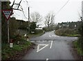
2
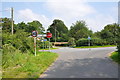
Crossroads at Harriot's Hayes
County Lane (unsurprisingly forming the boundary between Shropshire to the west, and Staffordshire to the east) crosses the lane from Harriot's Hayes to Codsall Wood
Image: © Richard Law
Taken: 16 May 2010
0.02 miles
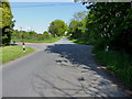
5
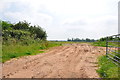
A sandy entrance into a field near Codsall Wood
Image: © Mick Malpass
Taken: 25 Jul 2012
0.17 miles
6
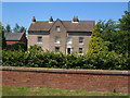
Harriots Hayes, Codsall Wood
An impressive old farmhouse on Harriots Hayes Road. Wide variety of spellings and use of apostrophe for the name appears on maps and in directories.
Image: © Derek Harper
Taken: 18 Jul 2006
0.21 miles
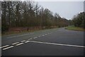
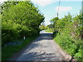
8
Crossroads on the outskirts of Codsall Wood
The road crossing the photo is Monarch's Way. This is reputed to be one of the roads King Charles II used on his way to Boscobel House after his defeat at Worcester.
Image: © Mick Malpass
Taken: 25 Jul 2012
0.25 miles
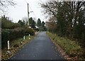
9
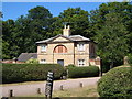
Lodge at southwest corner of Chillington estate
Victorian lodge at the edge of the village of Codsall Wood.
Image: © Derek Harper
Taken: 18 Jul 2006
0.25 miles