IMAGES TAKEN NEAR TO
Gunstone, WOLVERHAMPTON, WV8 1QQ
Introduction
This page details the photographs taken nearby to Gunstone, WV8 1QQ by members of the Geograph project.
The Geograph project started in 2005 with the aim of publishing, organising and preserving representative images for every square kilometre of Great Britain, Ireland and the Isle of Man.

There are currently over 7.5m images from over14,400 individuals and you can help contribute to the project by visiting https://www.geograph.org.uk
Image Map
Images are licensed for reuse under creativecommons.org/licenses/by-sa/2.0
Notes
- Clicking on the map will re-center to the selected point.
- The higher the marker number, the further away the image location is from the centre of the postcode.
Image Listing (17 Images Found)
Images are licensed for reuse under creativecommons.org/licenses/by-sa/2.0
Image
Details
Distance
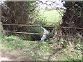
1
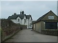
Gunstone Farm
The Staffordshire Way passes the Farm
Image: © Gordon Griffiths
Taken: 3 Jan 2008
0.02 miles
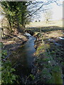
4
Tributary of the Moat Brook
Viewed upstream at Whitehouse Lane. The brook is fed from the Big Pool at Chillington Hall.
Image: © John M
Taken: 2 Apr 2011
0.15 miles
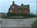
5
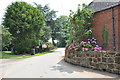
Whitehouse Lane at Gunstone
Some maps give Gunstone as being just up the road, but Google maps place it here.
Image: © Mick Malpass
Taken: 25 Jul 2012
0.16 miles
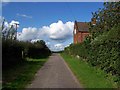
6
The Moat Brook
Starting life as a drain from Chillington Pool, the Moat Brook passes through the Pendeford Mill Nature Reserve in Image and then joins the River Penk.
Image: © Richard Law
Taken: 6 Apr 2013
0.16 miles
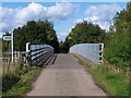
8
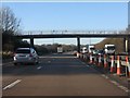
M54 Motorway - Staffordshire Way footbridge
Image: © Peter Whatley
Taken: 18 Jan 2011
0.18 miles
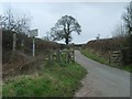
9
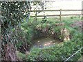
Lepers Well
Ancient sulphurous well beside Whitehouse Lane. The well is Grade 2 listed.
Image: © John M
Taken: 2 Apr 2011
0.19 miles