IMAGES TAKEN NEAR TO
Darwin Court, WOLVERHAMPTON, WV6 7TH
Introduction
This page details the photographs taken nearby to Darwin Court, WV6 7TH by members of the Geograph project.
The Geograph project started in 2005 with the aim of publishing, organising and preserving representative images for every square kilometre of Great Britain, Ireland and the Isle of Man.

There are currently over 7.5m images from over14,400 individuals and you can help contribute to the project by visiting https://www.geograph.org.uk
Image Map
Images are licensed for reuse under creativecommons.org/licenses/by-sa/2.0
Notes
- Clicking on the map will re-center to the selected point.
- The higher the marker number, the further away the image location is from the centre of the postcode.
Image Listing (198 Images Found)
Images are licensed for reuse under creativecommons.org/licenses/by-sa/2.0
Image
Details
Distance
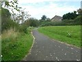
3
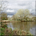
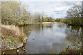
Upper Lake in Perton, Staffordshire
Looking north-ish. Upper Lake in Perton is also sometimes called Big Lake, and is fed by the infant River Penk which rises just under a mile to the east in Tettenhall Wood. A pleasant public footpath alongside the river (off to the left) leads northwards to the smaller Lower Lake.
Perton in South Staffordshire is a large village, effectively the edge of the Wolverhampton conurbation. Much of it was built in the late 20th century and early 21st century on the site of the former Perton Aerodrome which closed in July 1947, and adjacent farmland. https://pertonparishcouncil.gov.uk/about-the-parish/history-of-the-parish/ Since 2023 the village has started expanding into farmland west of Wrottesley Park Road.
Image: © Roger D Kidd
Taken: 2 Apr 2024
0.03 miles
4
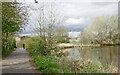
Lakeside path in Perton, Staffordshire
Looking north-west towards The Parkway and houses in Cabot Road. The path continues alongside the River Penk and towards the Lower Lake.
Image: © Roger D Kidd
Taken: 2 Apr 2024
0.04 miles
5
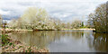
Upper Lake in Perton, Staffordshire
Looking north-east. Upper Lake in Perton is also sometimes called Big Lake, and is fed by the infant River Penk which rises just under a mile to the east in Tettenhall Wood. A pleasant public footpath alongside the river (off to the left) leads northwards to the smaller Lower Lake.
Perton in South Staffordshire is a large village, effectively the edge of the Wolverhampton conurbation. Much of it was built in the late 20th century and early 21st century on the site of the former Perton Aerodrome which closed in July 1947, and adjacent farmland. https://pertonparishcouncil.gov.uk/about-the-parish/history-of-the-parish/ Since 2023 the village has started expanding into farmland west of Wrottesley Park Road.
Image: © Roger D Kidd
Taken: 2 Apr 2024
0.04 miles
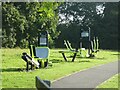
6
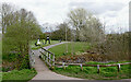
Park footpath in Perton, Staffordshire
Perton in South Staffordshire is a large village, effectively the edge of the Wolverhampton conurbation. Much of it was built in the late 20th century and early 21st century on the site of the former Perton Aerodrome which closed in July 1947, and adjacent farmland. https://pertonparishcouncil.gov.uk/about-the-parish/history-of-the-parish/ Since 2023 the village has started expanding into farmland west of Wrottesley Park Road.
The extensive housing surrounds the centre where there is a park including a lake, and a shopping precinct with supermarket, churches and a medical centre.
In this image, looking north-east, the lake is off to the right. The footbridge crosses the River Penk which flows off to the left.
Image: © Roger D Kidd
Taken: 2 Apr 2024
0.05 miles
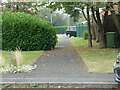
8
Upper Lake in Perton, Staffordshire
Looking north-east. The houses just over two hundred metres ahead are in Browning Grove.
Upper Lake in Perton is also sometimes called Big Lake, and is fed by the infant River Penk which rises just under a mile to the east in Tettenhall Wood. A pleasant public footpath alongside the river (off to the left) leads northwards to the smaller Lower Lake.
Perton in South Staffordshire is a large village, effectively the edge of the Wolverhampton conurbation. Much of it was built in the late 20th century and early 21st century on the site of the former Perton Aerodrome which closed in July 1947, and adjacent farmland. https://pertonparishcouncil.gov.uk/about-the-parish/history-of-the-parish/ Since 2023 the village has started expanding into farmland west of Wrottesley Park Road.
Image: © Roger D Kidd
Taken: 2 Apr 2024
0.05 miles