IMAGES TAKEN NEAR TO
Stableford Road, WOLVERHAMPTON, WV6 7JW
Introduction
This page details the photographs taken nearby to Stableford Road, WV6 7JW by members of the Geograph project.
The Geograph project started in 2005 with the aim of publishing, organising and preserving representative images for every square kilometre of Great Britain, Ireland and the Isle of Man.

There are currently over 7.5m images from over14,400 individuals and you can help contribute to the project by visiting https://www.geograph.org.uk
Image Map
Images are licensed for reuse under creativecommons.org/licenses/by-sa/2.0
Notes
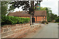
- Clicking on the map will re-center to the selected point.
- The higher the marker number, the further away the image location is from the centre of the postcode.
Image Listing (40 Images Found)
Images are licensed for reuse under creativecommons.org/licenses/by-sa/2.0
Image
Details
Distance
1
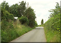
Stableford Road, Ackleton
Concentrating on the left side of Image
Image: © Derek Harper
Taken: 26 Jul 2019
0.02 miles
2
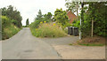
Stableford Road, Ackleton
On the right is the start of bridleway 0151 96/1. Beyond is a bank with rather a lot of ragwort.
Image: © Derek Harper
Taken: 26 Jul 2019
0.02 miles
3
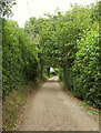
Bridleway, Ackleton
Bridleway 0151 96/1 beginning its journey to Badger.
Image: © Derek Harper
Taken: 26 Jul 2019
0.03 miles
4
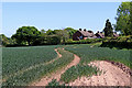
Farmland and housing near Ackleton in Shropshire
Looking east towards housing in Stableford Road.
Image: © Roger Kidd
Taken: 19 May 2020
0.05 miles
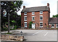
5
The Red Cow at Ackleton, closed for the afternoon
Image: © Row17
Taken: 1 Apr 2008
0.05 miles
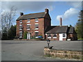
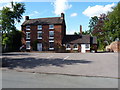
6
The Red Cow, Ackleton
Taken because of its representativeness of buildings in this part of the world. Red brick is the predominant material. This is late C18th. Grade II listed.
You can tell this photo was taken in the afternoon: Image] and Image
Image: © Stephen Richards
Taken: Unknown
0.06 miles
8
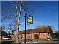
Red Cow Sign
The view of the Red Cow Pub Sign on Stableford Road, Ackleton.
Image: © Gordon Griffiths
Taken: 25 Mar 2019
0.06 miles
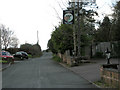
9
Sign, Red Cow, Ackleton
Plus the stretch of Stabledon Road passing the pub and the former tithe barn https://historicengland.org.uk/listing/the-list/list-entry/1053723 shown in Image
Image: © Derek Harper
Taken: 26 Jul 2019
0.06 miles
10
The Red Cow, Ackleton
It seems to have a habit of being closed of an afternoon... Image
Image: © Richard Law
Taken: 17 Jul 2010
0.06 miles