IMAGES TAKEN NEAR TO
Back Lane, WOLVERHAMPTON, WV6 7JJ
Introduction
This page details the photographs taken nearby to Back Lane, WV6 7JJ by members of the Geograph project.
The Geograph project started in 2005 with the aim of publishing, organising and preserving representative images for every square kilometre of Great Britain, Ireland and the Isle of Man.

There are currently over 7.5m images from over14,400 individuals and you can help contribute to the project by visiting https://www.geograph.org.uk
Image Map
Images are licensed for reuse under creativecommons.org/licenses/by-sa/2.0
Notes
- Clicking on the map will re-center to the selected point.
- The higher the marker number, the further away the image location is from the centre of the postcode.
Image Listing (37 Images Found)
Images are licensed for reuse under creativecommons.org/licenses/by-sa/2.0
Image
Details
Distance
1
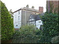
Ackleton Hall, Ackleton
The larger part of the hall, built of roughcast rendered brick, and which dates from the early 19th century, rather hides away behind surrounding buildings. It was Grade II listed https://britishlistedbuildings.co.uk/101053722-ackleton-hall-worfield#.XmFP4Kj7TIU & https://historicengland.org.uk/listing/the-list/list-entry/1053722 in 1974.
Image: © Richard Law
Taken: 1 Mar 2020
0.04 miles
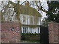
2
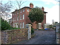
Ackleton House
Currently undergoing a little bit of attention, the rather fine Ackleton House dates from the late 18th century, and was Grade II listed https://britishlistedbuildings.co.uk/101053721-ackleton-house-worfield#.XmFO3Kj7TIU & https://historicengland.org.uk/listing/the-list/list-entry/1053721 in 1970.
Image: © Richard Law
Taken: 1 Mar 2020
0.08 miles
3

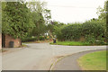
Back Lane
The view on Stableford Road, Ackleton.
Image: © Gordon Griffiths
Taken: 29 Aug 2017
0.08 miles
4
Junction, Ackleton
Where Back Lane (right) leaves Stableford Road.
Image: © Derek Harper
Taken: 26 Jul 2019
0.08 miles
5
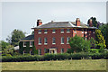
Ackleton House, Ackleton
A late-C18th Georgian house, always an uplifting sight. It has a Doric porch and the central bay is slightly more generously spaced to provide greater emphasis. Grade II listed.
Image: © Stephen Richards
Taken: Unknown
0.09 miles
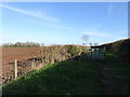
6
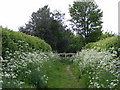
Hedged Path
The footpath runs through two hedges near Ackleton, Shropshire.
Image: © Gordon Griffiths
Taken: 21 May 2010
0.09 miles
8
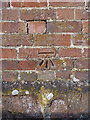
OS benchmark - Stableford, barn adjacent to The Red Cow
An OS cutmark on the gable wall of the Grade II listed barn to the east of the pub; originally levelled in 1961 at 81.674m above Ordnance Datum Newlyn.
Image: © Richard Law
Taken: 1 Mar 2020
0.11 miles
9
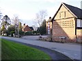
Pub Scene
The view of the Red Cow Pub on Stableford Road, Ackleton.
Image: © Gordon Griffiths
Taken: 18 Feb 2016
0.11 miles
10
Path Stile
The footpath near Ackleton, Shropshire.
Image: © Gordon Griffiths
Taken: 25 Mar 2019
0.11 miles