IMAGES TAKEN NEAR TO
Clive Road, WOLVERHAMPTON, WV6 7EN
Introduction
This page details the photographs taken nearby to Clive Road, WV6 7EN by members of the Geograph project.
The Geograph project started in 2005 with the aim of publishing, organising and preserving representative images for every square kilometre of Great Britain, Ireland and the Isle of Man.

There are currently over 7.5m images from over14,400 individuals and you can help contribute to the project by visiting https://www.geograph.org.uk
Image Map
Images are licensed for reuse under creativecommons.org/licenses/by-sa/2.0
Notes
- Clicking on the map will re-center to the selected point.
- The higher the marker number, the further away the image location is from the centre of the postcode.
Image Listing (70 Images Found)
Images are licensed for reuse under creativecommons.org/licenses/by-sa/2.0
Image
Details
Distance
1
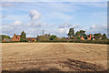
Stubble field by The Clive in Staffordshire
A telephoto assisted image looking across the corn field.
This is about a mile south of Pattingham.
The view north-east towards The Clive is from the bridleway which leads along the ridge of the sandstone escarpment. It is worth noting that the path is NOT across the middle of the field as still located on maps.
Image: © Roger Kidd
Taken: 16 Oct 2019
0.01 miles
2
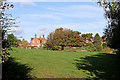
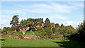
Pasture by The Clive in Staffordshire
The bridleway from Rudge Road leads along the edge of the field on the right, not across the middle of the field as shown on maps. Straight ahead is a fine old horse chestnut tree showing early autumn colours. To the left of it is The Clive Farm. To the right with lovely landscaped gardens is The Clive.
Image: © Roger Kidd
Taken: 16 Oct 2019
0.02 miles
3
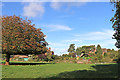
Pasture by The Clive in Staffordshire
The bridleway approaches Clive Road at the edge of the woodland on the right, not across the pasture field as shown on maps.
Image: © Roger Kidd
Taken: 16 Oct 2019
0.03 miles
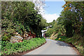
5
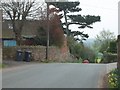
The crest of the hill by The Clive in Staffordshire
Clive Road has almost completed the climb up the sandstone escarpment. The road continues to Pattingham.
Image: © Roger Kidd
Taken: 16 Oct 2019
0.03 miles
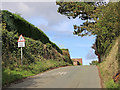
6
Clive Road south of Pattingham in Staffordshire
Clive Road is ascending the sandstone escarpment towards The Clive, then on towards Pattingham.
The Permo-Triassic rock crops out in several places nearby.
Image: © Roger Kidd
Taken: 16 Oct 2019
0.04 miles
7
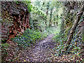
Bridleway near The Clive in Staffordshire
This bridleway has come from Bennett's Lane near Great Moor, and is about forty metres from its end at Clive Road. On the left a Permo-Triassic red sandstone exposure is about two metres high.
Image]
Image: © Roger Kidd
Taken: 16 Oct 2019
0.04 miles
8
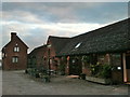
The Cowshed, Clive Farm, Pattingham
Once part of a dairy farm, now a restaurant.
Image: © Chris Whippet
Taken: 20 Jul 2012
0.04 miles
9
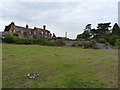
The Clive near Pattingham in Staffordshire
This substantial house is seen here from the bridleway at the southern edge of the field. Clive Farm is off to the left.
Image: © Roger Kidd
Taken: 16 Oct 2019
0.04 miles
10
The Clive
Clive Road from Pattingham passes through the Hamlet.
Image: © Gordon Griffiths
Taken: 12 Apr 2007
0.04 miles