IMAGES TAKEN NEAR TO
Gibbons Road, WOLVERHAMPTON, WV6 0JH
Introduction
This page details the photographs taken nearby to Gibbons Road, WV6 0JH by members of the Geograph project.
The Geograph project started in 2005 with the aim of publishing, organising and preserving representative images for every square kilometre of Great Britain, Ireland and the Isle of Man.

There are currently over 7.5m images from over14,400 individuals and you can help contribute to the project by visiting https://www.geograph.org.uk
Image Map
Images are licensed for reuse under creativecommons.org/licenses/by-sa/2.0
Notes
- Clicking on the map will re-center to the selected point.
- The higher the marker number, the further away the image location is from the centre of the postcode.
Image Listing (38 Images Found)
Images are licensed for reuse under creativecommons.org/licenses/by-sa/2.0
Image
Details
Distance
1
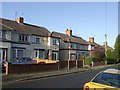
Council/Private Housing - Court Road
Houses on the Newbridge Estate built by the Council in 1923-4 were sold to meet a demand that could not be met at that time by private developers.
Image: © John M
Taken: 12 Dec 2009
0.03 miles
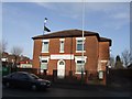
2
Council/Private Housing - Gibbons Road
Houses on the council built Newbridge Estate of 1923-4 were sold to meet a demand for private housing. The bay window may have been added as these were intended for private sale.
Image: © John M
Taken: 12 Dec 2009
0.03 miles
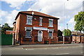
3
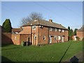
Housing - Gibbons Road
Three blocks face onto a central grassed area. The date is uncertain but it lies within an estate of 1923-4 properties built by the council and sold to private buyers in 1924.
Image: © John M
Taken: 12 Dec 2009
0.06 miles
4
The Summerhouse - a new lease of life?
The Summerhouse on the Newhampton Road/Lloyd Street corner has been closed for a long while; as I went past this morning, the steel shutters had been removed, and a job of painting was underway. By the evening, an amount of scaffolding was up at the front, and the titivation continued. There's hope for the old place yet.
Image: © Richard Law
Taken: 13 May 2009
0.08 miles
5
Hussaini Islamic Mission and Mosque
On Newhampton Road, Whitmore Reans.
Image: © John M
Taken: 5 Jan 2008
0.08 miles
6
Hussaini Islamic Mission and Ali (A.S) Mosque
A Shia Muslim welfare centre on Newhampton Road West.
Image: © Bill Boaden
Taken: 22 May 2011
0.08 miles
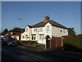
7
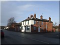
Hard times at the Summer House
Another local pub is closed and awaiting redevelopment.
Image: © John M
Taken: 5 Jan 2008
0.09 miles
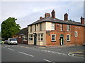
8
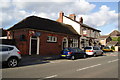
The Summer House
A pub on New Hampton Road West, which has reopened after a spell of closure.
Image: © Bill Boaden
Taken: 22 May 2011
0.10 miles
9

The Summer House in winter
The re-juvenated Summer House Image
Image: © John M
Taken: 12 Dec 2009
0.10 miles
10
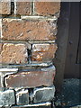
OS benchmark - Whitmore Reans, The Summerhouse
The badly damaged remains of an OS cutmark can (just about) be discerned on the half-brick in the centre of the shot. Only the horizontal datum line exists now, the arrow that's normally beneath it having been knocked off. This one was originally levelled at 120.689m above Ordnance Datum Newlyn.
Image: © Richard Law
Taken: 7 Sep 2014
0.10 miles