IMAGES TAKEN NEAR TO
Crowther Road, WOLVERHAMPTON, WV6 0HY
Introduction
This page details the photographs taken nearby to Crowther Road, WV6 0HY by members of the Geograph project.
The Geograph project started in 2005 with the aim of publishing, organising and preserving representative images for every square kilometre of Great Britain, Ireland and the Isle of Man.

There are currently over 7.5m images from over14,400 individuals and you can help contribute to the project by visiting https://www.geograph.org.uk
Image Map (Loading...)


Getting Data...Please wait
Leaflet Map data © OpenStreetMap
Images are licensed for reuse under creativecommons.org/licenses/by-sa/2.0
Notes
- Clicking on the map will re-center to the selected point.
- The higher the marker number, the further away the image location is from the centre of the postcode.
Image Listing (71 Images Found)
Images are licensed for reuse under creativecommons.org/licenses/by-sa/2.0
Image
Details
Distance
1
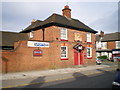
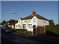
The Golden Eagle
A pub on the corner of Court Road and Hordern Road, between Aldersley and Whitmore Reans.
Image: © Richard Law
Taken: 13 May 2009
0.08 miles
2
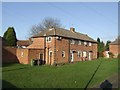
Housing - Gibbons Road
Three blocks face onto a central grassed area. The date is uncertain but it lies within an estate of 1923-4 properties built by the council and sold to private buyers in 1924.
Image: © John M
Taken: 12 Dec 2009
0.09 miles
3
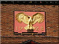
Detail on The Golden Eagle
Detail of the pub sign on the Golden Eagle. Clearly it was built in the mid 1920s, and was apparently contemporaneous with the Courtaulds factory on the opposite side of Hordern Road, which opened in the same year.
Image: © Richard Law
Taken: 13 May 2009
0.10 miles
4
The Golden Eagle
A pub on the corner of Court Road and Hordern Road.
Image: © Bill Boaden
Taken: 22 May 2011
0.10 miles
5
Council/Private Housing - Gibbons Road
Houses on the council built Newbridge Estate of 1923-4 were sold to meet a demand for private housing. The bay window may have been added as these were intended for private sale.
Image: © John M
Taken: 12 Dec 2009
0.11 miles
6
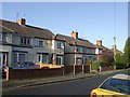
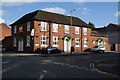
Council/Private Housing - Court Road
Houses on the Newbridge Estate built by the Council in 1923-4 were sold to meet a demand that could not be met at that time by private developers.
Image: © John M
Taken: 12 Dec 2009
0.11 miles
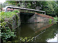
7
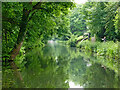
Canal near Newbridge in Wolverhampton
Looking south-west towards Compton, Wombourne, Kinver, Kidderminster and Stourport. This is the Staffordshire and Worcestershire Canal. There is a short arm and Victoria Wharf off to the right a short distance ahead.
Image: © Roger Kidd
Taken: 18 Jun 2013
0.14 miles
8
Staffordshire and Worcestershire Canal near Claregate in Wolverhampton
Looking north-easttowards Aldersley Junction Three quarters of a mile) and Autherley Junction (one and a quarter miles). There have been no fuel or other faciliies at Victoria Wharf (off to the left) for many years.
Image: © Roger Kidd
Taken: 18 May 2014
0.15 miles
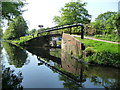
9
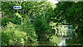
Canal arm entrance north of Newbridge, Wolverhampton
A short arm off the main line leads to Victoria Wharf where a former boat yard premises is now mainly used for caravan storage and moorings for two or three boats.
Image: © Roger D Kidd
Taken: 30 Aug 2010
0.15 miles
10
Private mooring, Victoria Arm, Staffs & Worcs Canal
My 1983 guidebook lists the Double Pennant Boatyard here. Their services included boat hire, a slipway, gas, engine repairs, mooring, chandlery and toilets.
Image: © Christine Johnstone
Taken: 7 May 2018
0.16 miles