IMAGES TAKEN NEAR TO
Admoor, WOLVERHAMPTON, WV5 7ED
Introduction
This page details the photographs taken nearby to Admoor, WV5 7ED by members of the Geograph project.
The Geograph project started in 2005 with the aim of publishing, organising and preserving representative images for every square kilometre of Great Britain, Ireland and the Isle of Man.

There are currently over 7.5m images from over14,400 individuals and you can help contribute to the project by visiting https://www.geograph.org.uk
Image Map
Images are licensed for reuse under creativecommons.org/licenses/by-sa/2.0
Notes
- Clicking on the map will re-center to the selected point.
- The higher the marker number, the further away the image location is from the centre of the postcode.
Image Listing (6 Images Found)
Images are licensed for reuse under creativecommons.org/licenses/by-sa/2.0
Image
Details
Distance
1

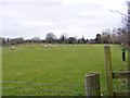
Good luck with that footpath
Supposedly, there's a right of way across those thistles in the field. We did the sensible thing, and followed the mown headland around the edge.
Image: © Richard Law
Taken: 26 May 2014
0.07 miles
2

Track from Admoor to Draycott
Some older map scales show it as a yellow lane, others as a white track. It is metalled, but used by little more than the residents of the cottages at Admoor.
Image: © Richard Law
Taken: 26 May 2014
0.12 miles
3
Stile View
The view of the footpath near Draycott in Shropshire.
Image: © Gordon Griffiths
Taken: 21 Mar 2016
0.17 miles
4
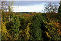
Rural Shropshire
View towards Halfpenny Green Vineyard from the Old Gate Inn at Heathton
Image: © Andy Keeling
Taken: 19 Nov 2006
0.18 miles
5
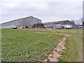
Whittimere Farm
The view of the Shropshire Farm north of Halfpenny Green in Staffordshire.
Image: © Gordon Griffiths
Taken: 21 Mar 2016
0.22 miles
6
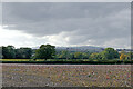
Staffordshire farmland east of Draycott
Looking west-south-west towards Draycott, half a mile distant. Brown Clee Hill on the skyline is about fifteen miles away.
Image: © Roger Kidd
Taken: 29 Sep 2020
0.24 miles