IMAGES TAKEN NEAR TO
Long Common, WOLVERHAMPTON, WV5 7AX
Introduction
This page details the photographs taken nearby to Long Common, WV5 7AX by members of the Geograph project.
The Geograph project started in 2005 with the aim of publishing, organising and preserving representative images for every square kilometre of Great Britain, Ireland and the Isle of Man.

There are currently over 7.5m images from over14,400 individuals and you can help contribute to the project by visiting https://www.geograph.org.uk
Image Map
Images are licensed for reuse under creativecommons.org/licenses/by-sa/2.0
Notes
- Clicking on the map will re-center to the selected point.
- The higher the marker number, the further away the image location is from the centre of the postcode.
Image Listing (15 Images Found)
Images are licensed for reuse under creativecommons.org/licenses/by-sa/2.0
Image
Details
Distance
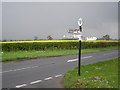
1
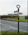
Signpost at Long Common, Shropshire
Not far from Seisdon in Staffordshire, and only into Shropshire by about three hundred metres, the arm pointing to Tinkers Castle appears to have corroded so much it fell off, and had to be riveted back on, with some fairly crude painted lettering. Wombourn is now almost always spelt Wombourne.
Image: © Roger D Kidd
Taken: 21 Jan 2009
0.08 miles
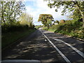
2
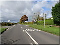
Long Common Junction
The view on the B4176 road in Shropshire.
Image: © Gordon Griffiths
Taken: 22 Oct 2020
0.08 miles
3
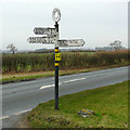
Signpost at Long Common, Shropshire
Only into Shropshire by about three hundred metres, the arm pointing to Tinkers Castle appears to have corroded so much it fell off, and had to be riveted back on, followed by some fairly crude painted lettering. Added to which, it is one and a half miles to Seisdon, so he/she with the black paint on his/her brush has not finished the job. Wombourne is commonly spelt with a concluding e these days. A spring time view can be seen here: Image]
Image: © Roger D Kidd
Taken: 21 Jan 2009
0.08 miles
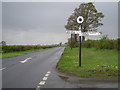
6
Shropshire Border
The view on the B4176 road in Staffordshire.
Image: © Gordon Griffiths
Taken: 22 Oct 2020
0.13 miles
7
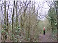
Abbots Castle Hill Walk
The view along the Staffordshire Way.
Image: © Gordon Griffiths
Taken: 2 Jan 2012
0.20 miles
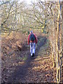
8
View South west from the Way
The Staffordshire Way at Long Common.
Image: © Gordon Griffiths
Taken: 11 Feb 2008
0.21 miles
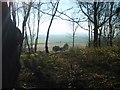
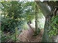
9
Path Scene
The view on Abbots Castle Hill part of the Staffordshire Way.
Image: © Gordon Griffiths
Taken: 5 Feb 2016
0.21 miles
10
Riding on Abbot's Castle Hill
Strictly speaking, it's a footpath, but since it appears to follow the line of a Roman Road, we reckoned it's been unfairly downgraded. That makes it fair game for a bit of trail poaching, as it runs along the ridge to the west of open farmland.
Image: © Richard Law
Taken: 27 Sep 2011
0.21 miles