IMAGES TAKEN NEAR TO
Pound Street, WOLVERHAMPTON, WV5 7AA
Introduction
This page details the photographs taken nearby to Pound Street, WV5 7AA by members of the Geograph project.
The Geograph project started in 2005 with the aim of publishing, organising and preserving representative images for every square kilometre of Great Britain, Ireland and the Isle of Man.

There are currently over 7.5m images from over14,400 individuals and you can help contribute to the project by visiting https://www.geograph.org.uk
Image Map (Loading...)


Getting Data...Please wait
Leaflet Map data © OpenStreetMap
Images are licensed for reuse under creativecommons.org/licenses/by-sa/2.0
Notes
- Clicking on the map will re-center to the selected point.
- The higher the marker number, the further away the image location is from the centre of the postcode.
Image Listing (172 Images Found)
Images are licensed for reuse under creativecommons.org/licenses/by-sa/2.0
Image
Details
Distance
1
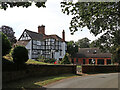
Powk Hall in Pound Street, Claverley, Shropshire
Powk Hall farmhouse is a seventeenth century timber framed building, with later additions. Grade II listed.
Image: © Roger Kidd
Taken: 8 Sep 2021
0.00 miles
2
Pound Street at the edge of the village of Claverley
The road climbs up to the centre of this attractive village, which is full of interesting buildings. It also still has three public houses, which is unusual for such a small place.
Image: © P L Chadwick
Taken: 11 Jun 2011
0.03 miles
3
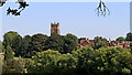
Claverley Approach
The view of the Village from the south west.
Image: © Gordon Griffiths
Taken: 26 Feb 2010
0.04 miles
4
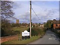
View towards Claverley in Shropshire
Looking east-north-east from the narrow lane which leads to Chyknell. All Saints Church (Grade I listed) is about 350 metres away.
Image: © Roger Kidd
Taken: 8 Sep 2021
0.06 miles
5
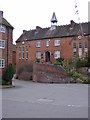
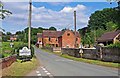
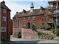
Claverley Old School
The former school stands in Pound Street at the junction with the Bull Ring.
Image: © Gordon Griffiths
Taken: 11 Aug 2012
0.07 miles
6
Former school in Claverley, Shropshire
The driveway leads to the former church school yard. The early 19th century Grade II listed building is on the right, part of the group including the Old Vicarage, the Bull Ring, the Lych Gates and All Saints Church. Pound Street leads off to the left. Clarecott is the early 19th century brick house past the school, also Grade II listed as part of the same group.
Image]
Image: © Roger D Kidd
Taken: 24 Jun 2011
0.08 miles
7
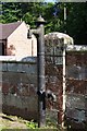
Old water pump, Pound Street, Claverley
It looks as if it has been here for many decades. It can also be seen, on the right, in this view of Pound Street. Image
Image: © P L Chadwick
Taken: 11 Jun 2011
0.08 miles
8
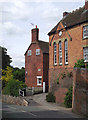
The Old School in Claverley Shropshire
At the top of Pound Street, this early 19th century building is Grade IIGV listed, together with other adjacent or nearby buildings. I notice two chimney pots have been added since my 2011 image.
Image: © Roger Kidd
Taken: 8 Sep 2021
0.08 miles
9
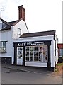
Sage Hair Studio, 4A High Street, Claverley
The business is known as Sage Hair Studio, although that name doesn't currently appear on the shop front. Both men and women are catered for. The premises used to be a commercial garage.
Image: © P L Chadwick
Taken: 11 Jun 2011
0.08 miles
10

OS benchmark - Claverley, wall on Pound St
An OS cutmark on a wall on the south side of Pound Street; originally levelled at 56.528m above Ordnance Datum Newlyn, and at that time described as being 0.4m above the ground. It's now more or less at ground level.
Image: © Richard Law
Taken: 6 Apr 2015
0.08 miles