IMAGES TAKEN NEAR TO
Farrington Road, WOLVERHAMPTON, WV4 6QH
Introduction
This page details the photographs taken nearby to Farrington Road, WV4 6QH by members of the Geograph project.
The Geograph project started in 2005 with the aim of publishing, organising and preserving representative images for every square kilometre of Great Britain, Ireland and the Isle of Man.

There are currently over 7.5m images from over14,400 individuals and you can help contribute to the project by visiting https://www.geograph.org.uk
Image Map (Loading...)


Getting Data...Please wait
Leaflet Map data © OpenStreetMap
Images are licensed for reuse under creativecommons.org/licenses/by-sa/2.0
Notes
- Clicking on the map will re-center to the selected point.
- The higher the marker number, the further away the image location is from the centre of the postcode.
Image Listing (152 Images Found)
Images are licensed for reuse under creativecommons.org/licenses/by-sa/2.0
Image
Details
Distance
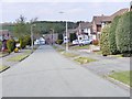
1
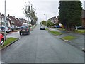
Farrington Road View
The view on the side of Sedgley Beacon in Wolverhampton's Ettingshall Park Estate.
Image: © Gordon Griffiths
Taken: 15 May 2012
0.02 miles
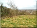
2
Beacon Fields View
The view over fields on the north side of Sedgley Beacon.
Image: © Gordon Griffiths
Taken: 18 Apr 2013
0.05 miles
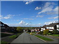
3
Farrington Road Scene
The view down the Wolverhampton road towards Goldthorn Hill. The road runs along the side of Sedgley Beacon.
Image: © Gordon Griffiths
Taken: 19 Dec 2020
0.05 miles
4
Grosvenor Road
The view from the Sedgley Beacon side road over farmland towards Wolverhampton.
Image: © Gordon Griffiths
Taken: 31 Aug 2010
0.06 miles
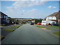
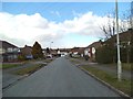
5
Grosvenor Road View
The view on Wolverhampton's Ettingshall Park Estate.
Image: © Gordon Griffiths
Taken: 24 Apr 2012
0.07 miles
6
Beacon Woods
The view north over the woods on the side of Sedgley Beacon.
Image: © Gordon Griffiths
Taken: 18 Apr 2013
0.07 miles
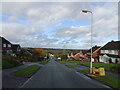
7
Beaconside View
The view down Farrington Road towards Goldthorn Hill. The road runs along the side of Sedgley Beacon in Wolverhampton.
Image: © Gordon Griffiths
Taken: 30 Mar 2024
0.08 miles
8
Farrington Road View
The view on Wolverhampton's Ettingshall Park Estate.
Image: © Gordon Griffiths
Taken: 11 Mar 2013
0.08 miles
9
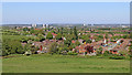
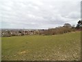
Pasture and Ettingshall Park housing, Wolverhampton
This view is from the public track on Beacon Hill, looking north-east across pasture and towards Ettingshall Park housing and Lanesfield, part of Wolverhampton.
On the skyline are the four tower blocks in Heath Town, Wolverhampton. To the right of those is the incinerator chimney at New Cross Hospital. To the right of that are the three tower blocks (two painted blue) in Wednesfield. In the far distance is the forestry of Cannock Chase.
Image: © Roger Kidd
Taken: 6 May 2020
0.08 miles
10
Farmland near Ettingshall Park, Wolverhampton
Looking north from the track leading down Beacon Hill towards Wolverhampton Road. The Beacon Centre for the Blind is on the left. https://www.beaconvision.org/locations/sedgley-2/ The four tower blocks in Heath Town can be seen. Centrally, on the skyline is the Victoria Hall student accommodation tower block. To the left of that are the city incinerator chimney, the Mander Centre car park, the dark tower of St Peter's Church, Mander House and then the spire of St John's in the Square.
Image: © Roger Kidd
Taken: 6 May 2020
0.08 miles