IMAGES TAKEN NEAR TO
Thurlstone Drive, WOLVERHAMPTON, WV4 5QL
Introduction
This page details the photographs taken nearby to Thurlstone Drive, WV4 5QL by members of the Geograph project.
The Geograph project started in 2005 with the aim of publishing, organising and preserving representative images for every square kilometre of Great Britain, Ireland and the Isle of Man.

There are currently over 7.5m images from over14,400 individuals and you can help contribute to the project by visiting https://www.geograph.org.uk
Image Map
Images are licensed for reuse under creativecommons.org/licenses/by-sa/2.0
Notes
- Clicking on the map will re-center to the selected point.
- The higher the marker number, the further away the image location is from the centre of the postcode.
Image Listing (353 Images Found)
Images are licensed for reuse under creativecommons.org/licenses/by-sa/2.0
Image
Details
Distance
1
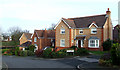
Modern Housing, Penn, Wolverhampton
These attractive, if rather densely built, houses were erected in the 1980s following the demolition and sale of Manor Road School (Colton Hills Lower School Annexe) and its playing fields.
Image: © Roger D Kidd
Taken: 1 Feb 2008
0.06 miles
2
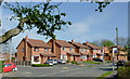
Modern housing on Wakeley Hill in Penn, Wolverhampton
Off to the left is The Fold. Wakeley Hill leads from near the A449 to Penn Common and the Barley Mow public house.
In Victorian times this was Wakeley Lane (not Hill), and was often called Workhouse Lane*. Before the building of the golf course, the old route also continued (unsurfaced) to Gospel End.
* Old tithe maps from the 1840s show the workhouse about 220 metres further up the hill, and on the right, past Butts Road. It is now called Ivy Terrace.
Image: © Roger D Kidd
Taken: 29 Mar 2012
0.06 miles
3
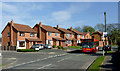
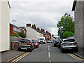
Housing and bus on Wakeley Hill, Penn, Wolverhampton
Off to the left is The Fold. The bus on Midland route 64 is a 1997 Dennis Dart Alexander ALX200 Demonstrator, reg P942EMS.
This used to be called Wakeley Lane, and also Workhouse Lane. Tithe maps show the workhouse to have been at the (current) Grade II listed Ivy Terrace, about 300 metres ahead on the right.
Image: © Roger D Kidd
Taken: 29 Mar 2012
0.06 miles
4
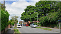
Wakeley Hill in Penn, Wolverhampton
Looking south-east from the junction with Church Hill. Wakeley Hill leads towards Colton Hills and Penn Golf Club.
In Victorian times this was Wakeley Lane (not Hill), was often called Workhouse Lane. Old tithe maps show the workhouse about three hundred metres up the hill, on the right, rather than in cottages here off to the left, which has been suggested.
Image: © Roger D Kidd
Taken: 10 Dec 2017
0.07 miles
5
Wakeley Hill in Penn, Wolverhampton
This is Wakeley Hill at the junction with Church Hill. Wakeley Hill leads towards Colton Hills and Penn Golf Club.
In Victorian times this was Wakeley Lane, though locally it was often called Workhouse Lane. Old tithe maps show the workhouse about three hundred metres ahead, on the right.
Image: © Roger D Kidd
Taken: 10 Dec 2017
0.07 miles
6
Wakeley Hill in Penn, Wolverhampton
Looking north-west towards Church Hill.
Image: © Roger D Kidd
Taken: 14 Jul 2024
0.07 miles
7
Butts Road in Penn, Wolverhampton
Butts Road is a cul-de-sac, seen here from Wakeley Hill by looking north-east towards Swan Bank (footpath link only).
Image: © Roger D Kidd
Taken: 14 Jul 2024
0.07 miles
8
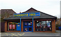
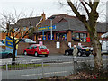
Blockbuster in Penn, Wolverhampton
I was disgruntled when a useful car park was converted into this business in the early 1990s. Now it is in administration due to the fact that its business plan has not kept up with changes in technology and alternative sourcing of movies in the twenty-first century.
Update: The building is now occupied by the very highly regarded White Cross Vets.
Image: © Roger D Kidd
Taken: 7 Feb 2013
0.07 miles
9
Blockbuster in Penn Road, Wolverhampton
I was disgruntled when a useful car park was converted into this business in the early 1990s. Now it is in administration due to the fact that its business plan has not kept up with changes in technology and alternative sourcing of movies in the twenty-first century.
The few car parking spaces this side of the wall are for the Co-op store/Post Office, off to the right.
Image: © Roger D Kidd
Taken: 7 Feb 2013
0.07 miles
10
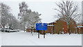
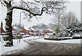
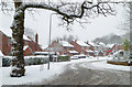
Penn United Reformed Church, Wolverhampton
This bleak deserted scene was timed at 13:31 on Sunday afternoon, and the thorough snow coverage makes me wonder whether an 11am service actually took place on this day.
Image: © Roger D Kidd
Taken: 10 Dec 2017
0.07 miles