IMAGES TAKEN NEAR TO
Leasowes Drive, WOLVERHAMPTON, WV4 4QB
Introduction
This page details the photographs taken nearby to Leasowes Drive, WV4 4QB by members of the Geograph project.
The Geograph project started in 2005 with the aim of publishing, organising and preserving representative images for every square kilometre of Great Britain, Ireland and the Isle of Man.

There are currently over 7.5m images from over14,400 individuals and you can help contribute to the project by visiting https://www.geograph.org.uk
Image Map
Images are licensed for reuse under creativecommons.org/licenses/by-sa/2.0
Notes
- Clicking on the map will re-center to the selected point.
- The higher the marker number, the further away the image location is from the centre of the postcode.
Image Listing (58 Images Found)
Images are licensed for reuse under creativecommons.org/licenses/by-sa/2.0
Image
Details
Distance
1
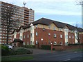
Langley Court
This 'very sheltered housing' scheme has been developed by Wolverhampton City Council in partnership with Anchor Housing Trust.
Image: © John M
Taken: 2 Dec 2006
0.04 miles
2
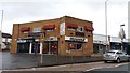
Shops and Restaurants at Five Ways, Merry Hill
These units form part of a local shopping centre located around a roundabout.
Image: © Paul Collins
Taken: 21 Oct 2017
0.05 miles
3
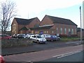
St Josephs
The foundation stone for the church in Coalway Road was laid in 1954 by the Bishop of Lichfield.
Image: © John M
Taken: 2 Dec 2006
0.05 miles
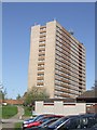
4
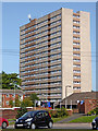
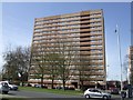
Highfields Court in Merry Hill, Wolverhampton
Looking north-east from Warstones Gardens near Warstones Drive. The tower block is Highfields Court, and is one of the three in Merry Hill, completed by Wimpey in 1968.
Image: © Roger Kidd
Taken: 17 Sep 2020
0.06 miles
5
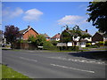
West end of Pinfold Grove, Merry Hill
Viewed from Leasowes Drive.
Image: © Richard Vince
Taken: 6 Jun 2013
0.07 miles
6
Council Housing - St Joseph's Court
One of three tower blocks built in 1967 on high ground at Merry Hill.
Image: © John M
Taken: 9 Apr 2011
0.07 miles
7
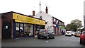
Shops at Five Ways, Merry Hill
These units form part of a local shopping centre located around a roundabout. There is the usual selection mainly comprising charity and betting shops, convenience stores and food establishments.
Image: © Paul Collins
Taken: 21 Oct 2017
0.07 miles
8
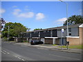
Housing on Leasowes Drive, Warstones estate
These houses are somewhat later, and rather less glazed, than most of the housing on the estate.
Image: © Richard Vince
Taken: 6 Jun 2013
0.09 miles
9
Council Housing - Pennwood Court
One of three tower blocks built in 1967 on high ground at Merry Hill.
Image: © John M
Taken: 9 Apr 2011
0.09 miles
10
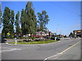
Five Ways, Merry Hill
This roundabout, the focal point of Merry Hill district centre, was used for turning by Wolverhampton Corporation's Merry Hill trolleybus route, latterly numbered 13 and operating from Low Hill (Pear Tree) via the town centre. The trolleybuses arrived via Trysull Road (on the right, flanked by bus shelters); the main bus service here still arrives that way, but nowadays it continues to Springhill.
Image: © Richard Vince
Taken: 6 Jun 2013
0.09 miles