IMAGES TAKEN NEAR TO
Coalway Road, WOLVERHAMPTON, WV3 7NN
Introduction
This page details the photographs taken nearby to Coalway Road, WV3 7NN by members of the Geograph project.
The Geograph project started in 2005 with the aim of publishing, organising and preserving representative images for every square kilometre of Great Britain, Ireland and the Isle of Man.

There are currently over 7.5m images from over14,400 individuals and you can help contribute to the project by visiting https://www.geograph.org.uk
Image Map
Images are licensed for reuse under creativecommons.org/licenses/by-sa/2.0
Notes
- Clicking on the map will re-center to the selected point.
- The higher the marker number, the further away the image location is from the centre of the postcode.
Image Listing (57 Images Found)
Images are licensed for reuse under creativecommons.org/licenses/by-sa/2.0
Image
Details
Distance
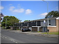
2
West end of Pinfold Grove, Merry Hill
Viewed from Leasowes Drive.
Image: © Richard Vince
Taken: 6 Jun 2013
0.08 miles
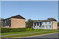
4
Council Housing - Pinfold Grove
Low rise housing built in the shadow of the three high rise blocks at Merry Hill. This housing is similar to types in the new towns with pedestrian access to the front of the properties.
Image: © John M
Taken: 9 Apr 2011
0.10 miles
5
Housing on Leasowes Drive, Warstones estate
These houses are somewhat later, and rather less glazed, than most of the housing on the estate.
Image: © Richard Vince
Taken: 6 Jun 2013
0.10 miles
6
Langley Court
This 'very sheltered housing' scheme has been developed by Wolverhampton City Council in partnership with Anchor Housing Trust.
Image: © John M
Taken: 2 Dec 2006
0.11 miles
7
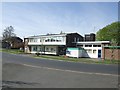
Warstones Health Centre
Health centre in Pinfold Grove.
Image: © John M
Taken: 9 Apr 2011
0.13 miles
8
Housing in Warstones Drive near Merry Hill, Wolverhampton
These are near the junction with Leasowes Drive.
Image: © Roger Kidd
Taken: 17 Sep 2020
0.13 miles
9
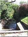
Merryhill Brook at Warstones
The brook appears to start on the west flank of Goldthorn Hill flowing towards the flats at Merry Hill where it enters a culvert. Emerging on the city boundary it falls to meet the Smestow Brook and onwards to join the River Severn.
Image: © John M
Taken: 9 Apr 2011
0.14 miles
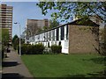
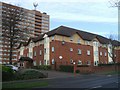
10
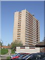
Council Housing - St Joseph's Court
One of three tower blocks built in 1967 on high ground at Merry Hill.
Image: © John M
Taken: 9 Apr 2011
0.14 miles