IMAGES TAKEN NEAR TO
Chapel Ash, WOLVERHAMPTON, WV3 0TY
Introduction
This page details the photographs taken nearby to Chapel Ash, WV3 0TY by members of the Geograph project.
The Geograph project started in 2005 with the aim of publishing, organising and preserving representative images for every square kilometre of Great Britain, Ireland and the Isle of Man.

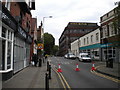
There are currently over 7.5m images from over14,400 individuals and you can help contribute to the project by visiting https://www.geograph.org.uk
Image Map
Images are licensed for reuse under creativecommons.org/licenses/by-sa/2.0
Notes
- Clicking on the map will re-center to the selected point.
- The higher the marker number, the further away the image location is from the centre of the postcode.
Image Listing (272 Images Found)
Images are licensed for reuse under creativecommons.org/licenses/by-sa/2.0
Image
Details
Distance
1
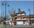
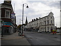
Shops at Chapel Ash, Wolverhampton
This is at the five-way junction where Chapel Ash becomes Tettenhall Road, Bath Road joins where Bella's shop is, and Merridale Road comes in (off to the left). Clifton Street is behind the camera.
Image: © Roger D Kidd
Taken: 9 Mar 2014
0.01 miles
2
Bath Road
A Bath Showroom in Bath Road.
Image: © Gordon Griffiths
Taken: 21 Oct 2007
0.01 miles
3
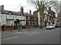
Wolverhampton, Combermere Arms
Pub at the West end of Chapel Ash (A41); internally, central corridor with counter, to left, bar, to right, two further rooms, courtyard. Outdoor gents' loo, built around lime tree. Cask ales on offer at my visit: Banks's Bitter, Original; Butcombe Brunel; Wychwood Hobgoblin; Deuchar's IPA. Good Beer Guide 2009-listed.
Image: © Mike Faherty
Taken: 26 Apr 2009
0.01 miles
4
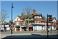
Chapel Ash crossroads in Wolverhampton
This is at the five-way junction where Chapel Ash becomes Tettenhall Road, Bath Road joins where Bella's shop is, and Merridale Road comes in (off to the left). Clifton Street is behind the camera.
Image: © Roger D Kidd
Taken: 9 Mar 2014
0.01 miles
5
West end of Bath Road, Wolverhampton
Looking towards the Banks's brewery from Chapel Ash, which was closed for resurfacing at the time (hence the cones).
Image: © Richard Vince
Taken: 24 Sep 2017
0.02 miles
6
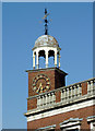
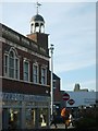
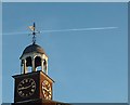
Clock tower at Chapel Ash, Wolverhampton
The clock tower is above the corner shop where Bath Road joins Chapel Ash. As you can see, the image was taken at 11:53 GMT! :-(
Image: © Roger D Kidd
Taken: 9 Mar 2014
0.02 miles
7
West end of Chapel Ash, Wolverhampton
One of the busiest junctions in Wolverhampton, it was caught almost completely devoid of vehicles on this occasion as the entire junction was closed for resurfacing.
Image: © Richard Vince
Taken: 24 Sep 2017
0.03 miles
8
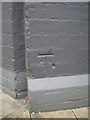
OS benchmark - the former Alexandra public house, Chapel Ash
OS cutmark in the brick frontage of the former Alexandra pub (now The Globe sports bar); the mark was originally levelled at 132.884m above Ordnance Datum Newlyn.
Image: © Richard Law
Taken: 22 Aug 2013
0.03 miles
10
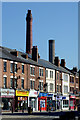
Shops and chimneys in Chapel Ash, Wolverhampton
Chapel Ash is the A41 (and A454) approaching the city centre from the west. The chimneys belong to Banks's brewery.
The 2007 Chapel Ash area conservation document makes very interesting reading.
http://www.wolverhampton.gov.uk/CHttpHandler.ashx?id=2600&p=0
Image: © Roger D Kidd
Taken: 9 Mar 2014
0.04 miles