IMAGES TAKEN NEAR TO
Graiseley Court, WOLVERHAMPTON, WV3 0NT
Introduction
This page details the photographs taken nearby to Graiseley Court, WV3 0NT by members of the Geograph project.
The Geograph project started in 2005 with the aim of publishing, organising and preserving representative images for every square kilometre of Great Britain, Ireland and the Isle of Man.

There are currently over 7.5m images from over14,400 individuals and you can help contribute to the project by visiting https://www.geograph.org.uk
Image Map
Images are licensed for reuse under creativecommons.org/licenses/by-sa/2.0
Notes
- Clicking on the map will re-center to the selected point.
- The higher the marker number, the further away the image location is from the centre of the postcode.
Image Listing (791 Images Found)
Images are licensed for reuse under creativecommons.org/licenses/by-sa/2.0
Image
Details
Distance
1
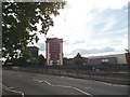
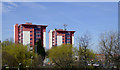
City Flats
The view across the Ring Road St Marks in Wolverhampton.
Image: © Gordon Griffiths
Taken: 4 Sep 2015
0.00 miles
2
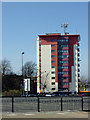
Hallet Drive flats in Wolverhampton
This is the northernmost of three such blocks in Hallet Drive, just outside the dual carriageway Ring Road St Mark's. The School Street car park is in the foreground.
Image: © Roger D Kidd
Taken: 9 Mar 2014
0.00 miles
3
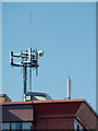
Communications equipment in Hallet Drive, Wolverhampton
This is on the roof of the northernmost of the three tower blocks in Hallet Drive.
Image: © Roger D Kidd
Taken: 9 Mar 2014
0.02 miles
4
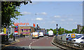
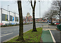
Ring Road St Mark's in Wolverhampton
The A150 (and A449), looking north from near the Penn Road Island.
Image: © Roger D Kidd
Taken: 24 May 2016
0.02 miles
5
Tower blocks in Wolverhampton
These blocks of flats are in Hallett Drive, by Ring Road St Marks, and have been photographed with telephoto assistance from the northern end of Paul Street by the redeveloped Sunbeam works.
Image: © Roger D Kidd
Taken: 25 Mar 2017
0.02 miles
6
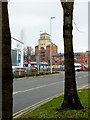
Great Brickkiln Street joining the Ring Road in Wolverhampton
This widened and rebuilt road is now a busy feeder route into and out of the new Sainsbury's supermarket, opened in the summer of 2014. The building on the left is a new gymnasium, part of the new complex. The 2003-2004 Market Place apartment block is beyond Ring Road St Mark's.
Image: © Roger D Kidd
Taken: 9 Feb 2015
0.02 miles
7
Great Brickkiln Street joining the Ring Road in Wolverhampton
This widened and rebuilt road is now a busy feeder route into and out of the new Sainsbury's supermarket, opened in the summer of 2014. The 2003-2004 Market Place apartment block is beyond Ring Road St Mark's. A new gymnasium has been built on the left as part of the Sainsbury's complex.
Image: © Roger D Kidd
Taken: 9 Feb 2015
0.02 miles
8
Great Brickkiln Street
The view down Great Brickkiln Street from the Ring Road in Wolverhampton.
Image: © Gordon Griffiths
Taken: 18 Jul 2017
0.02 miles
9
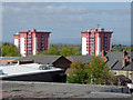
Tower blocks in Wolverhampton
A telephoto assisted image taken looking across the rooftops from the rooftop car park over the Wulfrun Centre. The blocks of flats (two out of the three shown here) are in Hallet Drive about 400 metres away.
The Wrekin can be seen on the horizon.
Image: © Roger D Kidd
Taken: 22 Apr 2017
0.02 miles
10
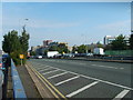
Ring Road St Marks
Wolverhampton Ring Road near to the markets.
Image: © Gordon Griffiths
Taken: 19 Sep 2008
0.03 miles