IMAGES TAKEN NEAR TO
The Oaklands, Lea Road, WOLVERHAMPTON, WV3 0LZ
Introduction
This page details the photographs taken nearby to The Oaklands, Lea Road, WV3 0LZ by members of the Geograph project.
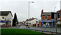
The Geograph project started in 2005 with the aim of publishing, organising and preserving representative images for every square kilometre of Great Britain, Ireland and the Isle of Man.

There are currently over 7.5m images from over14,400 individuals and you can help contribute to the project by visiting https://www.geograph.org.uk
Image Map
Images are licensed for reuse under creativecommons.org/licenses/by-sa/2.0
Notes
- Clicking on the map will re-center to the selected point.
- The higher the marker number, the further away the image location is from the centre of the postcode.
Image Listing (219 Images Found)
Images are licensed for reuse under creativecommons.org/licenses/by-sa/2.0
Image
Details
Distance
1
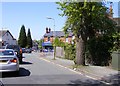
Lea Road Junction
The view in Merridale, Wolverhampton.
Image: © Gordon Griffiths
Taken: 5 May 2018
0.01 miles
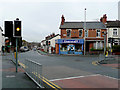
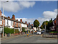
2
Lea Road near Graiseley in Wolverhampton
Looking west-south-west at the junction with Oaklands Road. Owen Road leads off towards Merridale, past the red car.
Image: © Roger Kidd
Taken: 10 Oct 2021
0.02 miles
3

Lea Road Scene
The view in Merridale, Wolverhampton.
Image: © Gordon Griffiths
Taken: 5 May 2018
0.02 miles
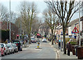
4
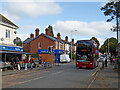
Lea Road near Graiseley in Wolverhampton
Looking north-east towards the junction with Owen Road and Oaklands Road; also the A449 Penn Road and Wolverhampton city centre.
Route No 2 is now a cross city service between Bushbury and Warstones.
The National Express bus (No 5409) dating from 2011 is an Alexander Dennis Enviro 400 Hybrid, apparently called Hayley!
Image: © Roger Kidd
Taken: 10 Oct 2021
0.02 miles
5
Lea Road near Graiseley in Wolverhampton
Looking north-east towards the junction with Owen Road and Oaklands Road; also the A449 Penn Road and Wolverhampton city centre.
Image: © Roger Kidd
Taken: 10 Oct 2021
0.02 miles
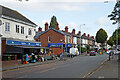
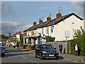
6
Crossroads on Lea Road, Penn Fields, Wolverhampton
Oaklands Road is behind the camera; Lea Road is to the left and right. Much of the area was developed in the late nineteenth and early twentieth centuries. Most corners had a shop on, and some of these are used as such even now, this being a multi-ethnic community in which small mini-markets and general stores are frequently found. Ahead along Owen Road about a hundred metres is a site where five roads converge (counting Owen Road as two!), and there are several well established small businesses, see Image] and other images.
Image: © Roger D Kidd
Taken: 8 Dec 2009
0.02 miles
7
Crossroads on Lea Road, Penn Fields, Wolverhampton
Oaklands Road is behind the camera; Lea Road is to the left and right. Much of the area was developed in the late nineteenth and early twentieth centuries. Most corners had a shop on, and some of these are used as such even now, this being a multi-ethnic community in which small mini-markets and general stores are frequently found. Ahead along Owen Road about a hundred metres is a site where five roads converge (counting Owen Road as two!), and there are several well established small businesses, see Image] and other images.
Image: © Roger D Kidd
Taken: 8 Dec 2009
0.02 miles
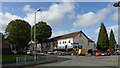
8
Lea Road in Penn Fields, Wolverhampton
This is a telephoto assisted image looking away from the city, towards the (recently installed) traffic lights where Owen Road leads off to the right, and Oaklands Road goes left to the A449 Penn Road. Clearly, Thursday is "bins" day!
Image: © Roger D Kidd
Taken: 21 Feb 2013
0.03 miles
9
Owen Road near Graiseley in Wolverhampton
Looking north-west towards Merridale and Bradmore, from the junction with Lea Road.
Nineteen months after the first Covid-19 full lockdown, restrictions no longer apply in England, but caution is still advised. I estimate less than 20% are wearing face masks outdoors in Wolverhampton, but more (up to 40%?) on public transport and in shops.
Image: © Roger Kidd
Taken: 10 Oct 2021
0.04 miles
10
Lea Road near Graiseley in Wolverhampton
Looking north-east towards the A449 Penn Road, and Wolverhampton city centre, from the junction with Oaklands Road.
Image: © Roger Kidd
Taken: 10 Oct 2021
0.05 miles