IMAGES TAKEN NEAR TO
Burleigh Road, WOLVERHAMPTON, WV3 0HW
Introduction
This page details the photographs taken nearby to Burleigh Road, WV3 0HW by members of the Geograph project.
The Geograph project started in 2005 with the aim of publishing, organising and preserving representative images for every square kilometre of Great Britain, Ireland and the Isle of Man.

There are currently over 7.5m images from over14,400 individuals and you can help contribute to the project by visiting https://www.geograph.org.uk
Image Map
Images are licensed for reuse under creativecommons.org/licenses/by-sa/2.0
Notes
- Clicking on the map will re-center to the selected point.
- The higher the marker number, the further away the image location is from the centre of the postcode.
Image Listing (143 Images Found)
Images are licensed for reuse under creativecommons.org/licenses/by-sa/2.0
Image
Details
Distance
1

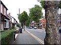
Bingley Street, Penn Fields, Wolverhampton
Owen Road is at the bottom of the slope. St Peter's Church tower in the city centre can be seen on the skyline.
Image: © Roger D Kidd
Taken: 17 Mar 2010
0.05 miles
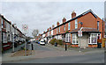
3
Housing in Lea Road, Wolverhampton
North-east of the junction with Claremont Road.
Image: © Roger Kidd
Taken: 10 Oct 2021
0.05 miles
4
Bingley Street
The view from Owen Road in Penn Fields, Wolverhampton.
Image: © Gordon Griffiths
Taken: 10 Aug 2017
0.05 miles
5
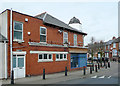
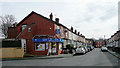
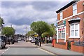
Burleigh Road, Penn Fields, Wolverhampton
This shows the extended corner shop at the junction with Owen Road. The short bell shaped tower is an architectural oddity among these late Victorian and early 20th century terraced shops and houses.
Image: © Roger D Kidd
Taken: 17 Mar 2010
0.06 miles
6
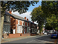
Norfolk Road, Penn Fields, Wolverhampton
This is at the junction with Bingley Street, looking towards Burleigh Road.
The area contains mainly late Victorian or early 20th terraced housing. The community is racially very mixed. Many corner shops still thrive, and other premises in some of the terraces support a variety of small businesses.
Image: © Roger D Kidd
Taken: 17 Mar 2010
0.06 miles
7
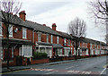
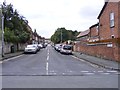
Terraced housing in Lea Road, Wolverhampton
Much of the Penn Fields area was developed in the late nineteenth and early twentieth centuries. Most corners had a shop on, and some of these are used as such even now, this being a multi-ethnic community in which small mini-markets and general stores are frequently found. These solid terraced houses have been well maintained and upgraded. New roofing (minus chimney stacks when central heating has been installed) is on many of them. This image of the Lea Road is by the junction with Lonsdale Road. Lea Road does have a bus route on it.
Image: © Roger D Kidd
Taken: 8 Dec 2009
0.06 miles
8
Norfolk Road, Penn Fields, Wolverhampton
Looking north-west from the junction with Burleigh Road. The area contains mainly late Victorian or early 20th terraced housing. The community is racially very mixed. Many corner shops still thrive, and other premises in some of the terraces support a variety of small businesses.
Image: © Roger D Kidd
Taken: 17 Mar 2010
0.06 miles
9
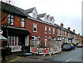
New building in Owen Road, Penn Fields, Wolverhampton
Until recently there was a space between the shop and the next house, probably built in late Victorian or early Edwardian times. I will appreciate any local historian contacting me about the history of this gap. It can just be seen on the left in this image: Image]
Image: © Roger D Kidd
Taken: 8 Dec 2009
0.06 miles
10
Owen Road Junction
The view of the five way road junction in Penn Fields, Wolverhampton.
Image: © Gordon Griffiths
Taken: 1 May 2018
0.06 miles