IMAGES TAKEN NEAR TO
Owen Road, WOLVERHAMPTON, WV3 0HH
Introduction
This page details the photographs taken nearby to Owen Road, WV3 0HH by members of the Geograph project.
The Geograph project started in 2005 with the aim of publishing, organising and preserving representative images for every square kilometre of Great Britain, Ireland and the Isle of Man.

There are currently over 7.5m images from over14,400 individuals and you can help contribute to the project by visiting https://www.geograph.org.uk
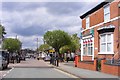
Image Map (Loading...)


Getting Data...Please wait
Leaflet Map data © OpenStreetMap
Images are licensed for reuse under creativecommons.org/licenses/by-sa/2.0
Notes
- Clicking on the map will re-center to the selected point.
- The higher the marker number, the further away the image location is from the centre of the postcode.
Image Listing (180 Images Found)
Images are licensed for reuse under creativecommons.org/licenses/by-sa/2.0
Image
Details
Distance
1

Owen Road, Wolverhampton
Showing position of Postbox No. WV3 118.
See Image] for postbox.
Image: © JThomas
Taken: 22 Aug 2019
0.01 miles
2
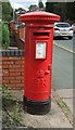
George V postbox on Owen Road, Wolverhampton
Postbox No. WV3 118.
See Image] for context.
Image: © JThomas
Taken: 22 Aug 2019
0.01 miles
3
Owen Road near Blakenhall in Wolverhampton
Looking north-west towards Merridale and Bradmore, from the junction with Lea Road.
Image: © Roger Kidd
Taken: 10 Oct 2021
0.01 miles
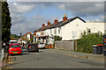
4
Owen Road in Penn Fields, Wolverhampton
Seen from near the junction with Lea Road.
Image: © Roger D Kidd
Taken: 21 Feb 2013
0.01 miles
5
Owen Road, Penn Fields, Wolverhampton
Looking from the crossroads at Burleigh Road towards Lea Road and Oaklands Road. Owen Road and the roads radiating at this junction are now a 20 mph zone with various ridges and bumps on the road surface designed to reduce traffic speed.
Image: © Roger D Kidd
Taken: 17 Mar 2010
0.01 miles
6
Owen Road Junction
The view of the five way road junction in Penn Fields, Wolverhampton.
Image: © Gordon Griffiths
Taken: 1 May 2018
0.02 miles
7
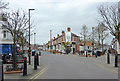
Five way road junction in Penn Fields, Wolverhampton
Several corner shops still trade at this meeting of roads from five directions. Owen Road passes by Dalton Street, Manlove Street and Burleigh Road. This is a 20mph area.
Image: © Roger D Kidd
Taken: 21 Feb 2013
0.02 miles
8
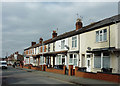
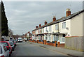
Terraced housing in Penn Fields, Wolverhampton
This is Owen Road between Lea Road and the junction with Dalton Street.
Image: © Roger D Kidd
Taken: 21 Feb 2013
0.02 miles
9
Owen Road near Graiseley in Wolverhampton
Looking north-west towards Merridale and Bradmore, from the junction with Lea Road.
Nineteen months after the first Covid-19 full lockdown, restrictions no longer apply in England, but caution is still advised. I estimate less than 20% are wearing face masks outdoors in Wolverhampton, but more (up to 40%?) on public transport and in shops.
Image: © Roger Kidd
Taken: 10 Oct 2021
0.02 miles
10
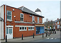
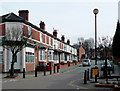
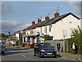
Burleigh Road, Penn Fields, Wolverhampton
This shows the extended corner shop at the junction with Owen Road. The short bell shaped tower is an architectural oddity among these late Victorian and early 20th century terraced shops and houses.
Image: © Roger D Kidd
Taken: 17 Mar 2010
0.02 miles