IMAGES TAKEN NEAR TO
Graiseley Hill, WOLVERHAMPTON, WV2 4HQ
Introduction
This page details the photographs taken nearby to Graiseley Hill, WV2 4HQ by members of the Geograph project.
The Geograph project started in 2005 with the aim of publishing, organising and preserving representative images for every square kilometre of Great Britain, Ireland and the Isle of Man.

There are currently over 7.5m images from over14,400 individuals and you can help contribute to the project by visiting https://www.geograph.org.uk
Image Map
Images are licensed for reuse under creativecommons.org/licenses/by-sa/2.0
Notes
- Clicking on the map will re-center to the selected point.
- The higher the marker number, the further away the image location is from the centre of the postcode.
Image Listing (256 Images Found)
Images are licensed for reuse under creativecommons.org/licenses/by-sa/2.0
Image
Details
Distance
1
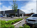
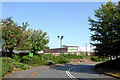
Jaguar Sales
The view on the Penn Road in Wolverhampton.
Image: © Gordon Griffiths
Taken: 6 Jul 2021
0.01 miles
2
Ready for Development.
A factory has recently been demolished. This was the site of the AJS Motor Cycle Graisley Hill works, until 1931. I believe it will now be used for housing.
Image: © Annette Randle
Taken: 27 Jun 2008
0.01 miles
3
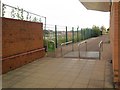
Footpath to Graiseley Hill
On the left a demolished factory site, on the right Waitrose supermarket. The spire of St. John's church can be seen in the distance.
Image: © Annette Randle
Taken: 20 Jun 2008
0.02 miles
4
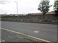
Penn Road View
The view along the dual carriageway in Wolverhampton.
Image: © Gordon Griffiths
Taken: 5 Nov 2017
0.03 miles
5
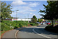
Waitrose approach road in Wolverhampton
The supermarket was built for Safeway in the early 1980s(?), and was taken over by Morrison's in February 2004. Within a year or so Morrison's were forced to sell it on to Waitrose because of "competition regulation" laws. In September 2020 it was announced that the store would be closing on 31 December, and would be operated by Tesco from early 2021.
Image]
Image: © Roger Kidd
Taken: 17 Sep 2020
0.04 miles
6
Tesco approach road in Wolverhampton
The supermarket by Penn Road/Marston Road was built for Safeway in the early 1980s(?), and was taken over by Morrison's in February 2004. Within a year or so Morrison's were forced to sell it on to Waitrose because of "competition regulation" laws. In September 2020 it was announced that the store would be closing on 31 December, and would be operated by Tesco from early 2021.
Tesco re-opened the doors on 30 June 2021.
Image]
Image: © Roger Kidd
Taken: 15 Sep 2021
0.04 miles
7
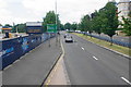
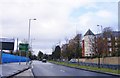
Penn Road
The A449 heading away from Wolverhampton. There is a development site on the left and Pennant Court on the right.
Image: © Bill Boaden
Taken: 22 Jun 2018
0.04 miles
8
Graiseley Hill in Wolverhampton
Looking north-west from near the primary school. Behind the new boarding on the right is part of the former Metal Castings Ltd site. The works closed in 2004 after more than a hundred years on the site, and to the left of the road also.
A new Jaguar Land Rover hub is planned for 2017-2018.
Image: © Roger D Kidd
Taken: 1 May 2017
0.05 miles
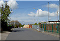
9
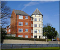
Apartments by Penn Road, Wolverhampton
The apartments are in Pennant Court, off the Penn Road (north carriageway).
Image: © Roger D Kidd
Taken: 25 Mar 2017
0.05 miles
10
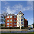
Apartments in Pennant Court, Wolverhampton
Pennant Court is off the A449 Penn Road (northbound carriageway) and was built in the early-mid 2000s on the site formerly occupied by the YMCA and The Mount (Wolverhampton Education Department).
Image: © Roger D Kidd
Taken: 25 Mar 2017
0.05 miles