IMAGES TAKEN NEAR TO
The Down, BRIDGNORTH, WV16 6AL
Introduction
This page details the photographs taken nearby to WV16 6AL by members of the Geograph project.
The Geograph project started in 2005 with the aim of publishing, organising and preserving representative images for every square kilometre of Great Britain, Ireland and the Isle of Man.

There are currently over 7.5m images from over14,400 individuals and you can help contribute to the project by visiting https://www.geograph.org.uk
Image Map
Images are licensed for reuse under creativecommons.org/licenses/by-sa/2.0
Notes
- Clicking on the map will re-center to the selected point.
- The higher the marker number, the further away the image location is from the centre of the postcode.
Image Listing (10 Images Found)
Images are licensed for reuse under creativecommons.org/licenses/by-sa/2.0
Image
Details
Distance
1
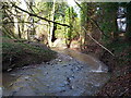
The Borle Brook
The stream rises in the area of Meadowley and Upton Cressett to the northwest of here, then heads south and east beyond Billingsley to join the Severn just south of Highley, where the rather magnificent Image is found.
Image: © Richard Law
Taken: 16 Feb 2014
0.05 miles
2
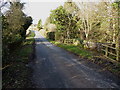
Down Mill bridge on Milfields Way
The bridge carries the lane from The Down to Eudon George across the Borle Brook. There is (or more likely was) an OS benchmark on the end of the sunlit parapet wall nearest to the camera, but it's either obscured by ivy/the fence, or the wall has been rebuilt since the mark was originally cut.
Image: © Richard Law
Taken: 16 Feb 2014
0.05 miles
3
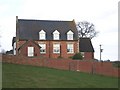
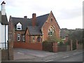
The Old Down School
Now converted to a private residence, this would formerly have been the local primary school.
Image: © Richard Law
Taken: 14 Mar 2009
0.10 miles
4
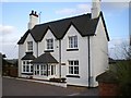
The old Schoolhouse at The Down
This is the old schoolhouse attached to the Old School in Image It's also converted to a private residence these days.
Image: © Richard Law
Taken: 14 Mar 2009
0.11 miles
6
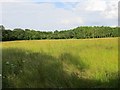
Long grass, Eudon
Awaiting cutting, probably for silage.
Image: © Richard Webb
Taken: 30 Jun 2014
0.11 miles
7
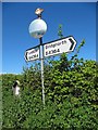
Old Direction Sign - Signpost by the B4364, The Down, Neenton parish
Fan finial - 2 Worboys arms; Shropshire parish fan by the B4364, in parish of Neenton (Bridgnorth District), The Down.
Surveyed
Milestone Society National ID: SA_SO6890
Image: © Milestone Society
Taken: Unknown
0.13 miles
9
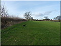
Footpath back up to The Down
A walk with Daft Dog and a chance (for him) to sniff out pheasants in the hedgerow - more entertaining for both of us than sitting in the pub on a pleasant Sunday afternoon.
Image: © Richard Law
Taken: 16 Feb 2014
0.17 miles
10
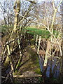
Footbridge over the Borle Brook
A small bridge carrying a path through damp fields across the Borle. Daft Dog enjoyed the scent of pheasants around this way.
Image: © Richard Law
Taken: 16 Feb 2014
0.23 miles