IMAGES TAKEN NEAR TO
Old Worcester Road, BRIDGNORTH, WV15 6QE
Introduction
This page details the photographs taken nearby to Old Worcester Road, WV15 6QE by members of the Geograph project.
The Geograph project started in 2005 with the aim of publishing, organising and preserving representative images for every square kilometre of Great Britain, Ireland and the Isle of Man.

There are currently over 7.5m images from over14,400 individuals and you can help contribute to the project by visiting https://www.geograph.org.uk
Image Map
Images are licensed for reuse under creativecommons.org/licenses/by-sa/2.0
Notes
- Clicking on the map will re-center to the selected point.
- The higher the marker number, the further away the image location is from the centre of the postcode.
Image Listing (16 Images Found)
Images are licensed for reuse under creativecommons.org/licenses/by-sa/2.0
Image
Details
Distance
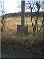
1
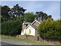
Old Toll House, Danesford
Toll House in the parish of Eardington, Tollgate Cottage at the junction of Old Worcester Road and the A442.
Shropshire HER.
HER Number (PRN): 15323 https://www.heritagegateway.org.uk/Gateway/Results_Single.aspx?uid=MSA17229&resourceID=1015
Surveyed
Milestone Society National ID: SA.BNT02
Image: © Milestone Society
Taken: Unknown
0.04 miles
2
The Danesford milepost in its setting beside the A442
Image: © Richard Law
Taken: 14 Mar 2010
0.05 miles
3
The Danesford milepost - detail
Not the best-preserved cast iron milepost I've come across, but at least it's still there, unlike the one marked on some maps in Image, which I couldn't find at all.
Image: © Richard Law
Taken: 14 Mar 2010
0.05 miles
4
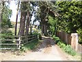
Driveway to Spring Valley
The public footpath uses this for a distance before following the boundary wall of the Quatford Castle grounds.
Image: © John M
Taken: 5 May 2007
0.05 miles
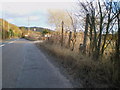
5
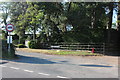
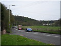
Old Worcester Road at the junction of the A442
Image: © David Howard
Taken: 30 May 2020
0.05 miles
6
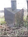
Old Milepost by the A442, Danesford, Bridgnorth parish
Cast iron post by the A442, in parish of Bridgnorth (Bridgnorth District), West of Quatford Castle, Danesford, on South side of road. Erected by the Kidderminster turnpike trust in the 19th century. Damaged.
Inscription reads:-
: TO / BRID. / 1 : : TO (LONDON) / (13)5 / MILES : : TO / KID. / 12 :
Shropshire HER.
HER Number (PRN): 21108 https://www.heritagegateway.org.uk/Gateway/Results_Single.aspx?uid=MSA23681&resourceID=1015
Milestone Society National ID: SA_BNKD01
Image: © A Reade/J Higgins
Taken: 30 Jan 2005
0.06 miles
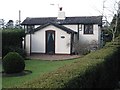
7
Lodge to Quatford Castle
Quatford Castle is an 1830s building reached via a private drive.
Image: © John M
Taken: 5 May 2007
0.07 miles
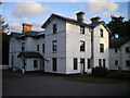
9
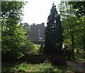
Quatford Castle
The current building was built by John Smalman in 1830.
Image: © John M
Taken: 5 May 2007
0.17 miles