IMAGES TAKEN NEAR TO
Danesford, BRIDGNORTH, WV15 6QD
Introduction
This page details the photographs taken nearby to WV15 6QD by members of the Geograph project.
The Geograph project started in 2005 with the aim of publishing, organising and preserving representative images for every square kilometre of Great Britain, Ireland and the Isle of Man.

There are currently over 7.5m images from over14,400 individuals and you can help contribute to the project by visiting https://www.geograph.org.uk
Image Map
Images are licensed for reuse under creativecommons.org/licenses/by-sa/2.0
Notes
- Clicking on the map will re-center to the selected point.
- The higher the marker number, the further away the image location is from the centre of the postcode.
Image Listing (11 Images Found)
Images are licensed for reuse under creativecommons.org/licenses/by-sa/2.0
Image
Details
Distance
2
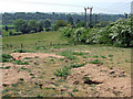
Rough Ground, Danesford, Shropshire
The soil is so poor and sandy on this hillside that it is barely usable for grazing. Rabbits abound!
Image: © Roger Kidd
Taken: 5 May 2007
0.08 miles
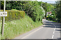
4
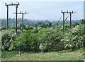
Power Poles and May Hedge, Danesford, Shropshire
Image: © Roger Kidd
Taken: 5 May 2007
0.14 miles
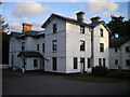
5
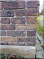
OS benchmark - Danesford, building by Danesford Manor
An OS cutmark on a roadside building at Danesford; originally levelled, probably in 1960, at 39.865m above Ordnance Datum Newlyn.
Image: © Richard Law
Taken: 3 Dec 2017
0.23 miles
6
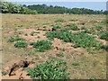
Rough Ground and Rabbit Holes, Danesford, Shropshire
The soil layer is so shallow, crumbly and sandy that it barely supports grass for grazing. Rabbit burrows are plentiful.
Image: © Roger Kidd
Taken: 5 May 2007
0.24 miles
9
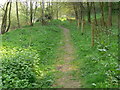
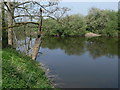
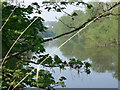
The Severn Way at Cliff Coppice
On the southern bank of the River Severn near Bridgnorth.
Image: © Mat Fascione
Taken: 21 Apr 2011
0.24 miles