IMAGES TAKEN NEAR TO
Greenway Avenue, BRIDGNORTH, WV15 6NY
Introduction
This page details the photographs taken nearby to Greenway Avenue, WV15 6NY by members of the Geograph project.
The Geograph project started in 2005 with the aim of publishing, organising and preserving representative images for every square kilometre of Great Britain, Ireland and the Isle of Man.

There are currently over 7.5m images from over14,400 individuals and you can help contribute to the project by visiting https://www.geograph.org.uk
Image Map
Images are licensed for reuse under creativecommons.org/licenses/by-sa/2.0
Notes
- Clicking on the map will re-center to the selected point.
- The higher the marker number, the further away the image location is from the centre of the postcode.
Image Listing (60 Images Found)
Images are licensed for reuse under creativecommons.org/licenses/by-sa/2.0
Image
Details
Distance
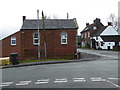
1
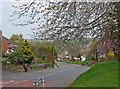
Daddlebrook Road near its junction with Church Road
The quaintly named Daddlebrook Road is a long road traversing the newer part of the village of Alveley, which for a few decades in the 20th century was a mining village. This part of the road is near its junction with the main road in the older part of the village. The orange signs, which can be glimpsed in the distance, are posters for the local Liberal Democrat candidate in the 2010 General Election.
Image: © P L Chadwick
Taken: 18 Apr 2010
0.09 miles
2
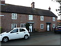
52 & 53 Ivy Place, Alveley
The northern half of a row of sandstone cottages dating from the late 18th or early 19th centuries, which were Grade II listed https://www.britishlistedbuildings.co.uk/101053197-50-53-ivy-place-alveley#.WjOFjYZl-M8 in 1974. The other two (off shot to the left) are very similar, but were obscured by a parked lorry on this particular day.
Image: © Richard Law
Taken: 3 Dec 2017
0.11 miles
3
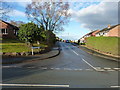
Holmes Orchard
An estate of probably 1980s housing, built on what was presumably an old apple orchard.
Image: © Richard Law
Taken: 3 Dec 2017
0.12 miles
5
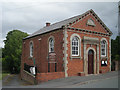
Alveley Old Chapel
Former Primitive Methodist Chapel, built in 1862. The last service held at the chapel was in 2011 and it has now been reopened as a cafe and village hub.
Image: © Eirian Evans
Taken: 11 Jan 2016
0.13 miles
6
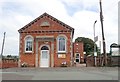
Alveley Methodist Church
Former Primitive Methodist Chapel, built in 1862
Image: © Eirian Evans
Taken: 23 Aug 2019
0.13 miles
7
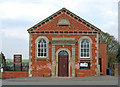
Alveley Methodist Church (former Primitive Methodist Chapel), Church Road
It comes as rather a shock to find a former Primitive Methodist Chapel still in use by the Methodists. But this one in Alveley remains in use, having passed to the Methodist Church when the Primitive Methodists became one of its constituent founders in the early 1930's. The chapel was built in 1862.
Image
Image: © P L Chadwick
Taken: 18 Apr 2010
0.13 miles
8
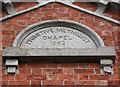
Alveley Methodist Church (former Primitive Methodist Chapel) - detail, Church Road
The name and date appear on the top of the Church Road frontage of the building. There is further writing below the date but it is difficult to read.
Image
Image: © P L Chadwick
Taken: 18 Apr 2010
0.13 miles
9
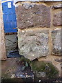
Old OS benchmark - Alveley, The Three Horseshoes
This mark is no longer recorded by the OS, but was first marked on the 1883 map at 385.1ft above sea level, presumably Ordnance Datum Liverpool. It has weathered somewhat in the last 130 years.
Image: © Richard Law
Taken: 3 Dec 2017
0.14 miles
10
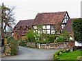
Old house on corner of Centre Place
One of several attractive old houses and cottages to be found within a few hundred yards of St. Mary's Parish Church.
Image: © P L Chadwick
Taken: 18 Apr 2010
0.14 miles