IMAGES TAKEN NEAR TO
Daddlebrook Road, BRIDGNORTH, WV15 6NU
Introduction
This page details the photographs taken nearby to Daddlebrook Road, WV15 6NU by members of the Geograph project.
The Geograph project started in 2005 with the aim of publishing, organising and preserving representative images for every square kilometre of Great Britain, Ireland and the Isle of Man.

There are currently over 7.5m images from over14,400 individuals and you can help contribute to the project by visiting https://www.geograph.org.uk
Image Map
Images are licensed for reuse under creativecommons.org/licenses/by-sa/2.0
Notes
- Clicking on the map will re-center to the selected point.
- The higher the marker number, the further away the image location is from the centre of the postcode.
Image Listing (60 Images Found)
Images are licensed for reuse under creativecommons.org/licenses/by-sa/2.0
Image
Details
Distance
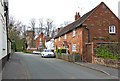
1
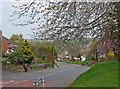
Daddlebrook Road near its junction with Church Road
The quaintly named Daddlebrook Road is a long road traversing the newer part of the village of Alveley, which for a few decades in the 20th century was a mining village. This part of the road is near its junction with the main road in the older part of the village. The orange signs, which can be glimpsed in the distance, are posters for the local Liberal Democrat candidate in the 2010 General Election.
Image: © P L Chadwick
Taken: 18 Apr 2010
0.04 miles
2
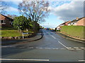
Holmes Orchard
An estate of probably 1980s housing, built on what was presumably an old apple orchard.
Image: © Richard Law
Taken: 3 Dec 2017
0.05 miles
3
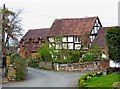
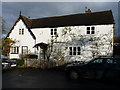
Old house on corner of Centre Place
One of several attractive old houses and cottages to be found within a few hundred yards of St. Mary's Parish Church.
Image: © P L Chadwick
Taken: 18 Apr 2010
0.08 miles
4
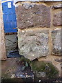
Old OS benchmark - Alveley, The Three Horseshoes
This mark is no longer recorded by the OS, but was first marked on the 1883 map at 385.1ft above sea level, presumably Ordnance Datum Liverpool. It has weathered somewhat in the last 130 years.
Image: © Richard Law
Taken: 3 Dec 2017
0.09 miles
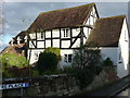
5
17 Centre Place, Alveley
One half of a pair of Grade II listed https://www.britishlistedbuildings.co.uk/101053195-16-and-17-centre-place-alveley#.WixGb9SLTGg cottages (granted in 1970) which date from the 18th century. The other one of the pair is at Image, and they form part of a group of listed buildings in the historic middle of the village.
Image: © Richard Law
Taken: 3 Dec 2017
0.09 miles
6
19 - 21 Centre Place, Alveley
A pair of late 18th or early 19th century sandstone rubble-built cottages, which were Grade II listed https://www.britishlistedbuildings.co.uk/101176597-19-21-centre-place-alveley#.WixFTNSLTGg in 1970. The centre of the village around the church comprises a series of grouped listed buildings.
Image: © Richard Law
Taken: 3 Dec 2017
0.09 miles
7
7 Centre Place, Alveley
Another of several attractive Grade II listed https://www.britishlistedbuildings.co.uk/101367872-7-centre-place-alveley#.WixIgtSLTGg properties in the middle of the village; this dates from the 17th century and is described in its listing details as 'unoccupied' in 1970. That's clearly no longer the case.
Image: © Richard Law
Taken: 3 Dec 2017
0.10 miles
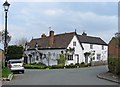
8
Road leading to the church
The white wall on the left belongs to The Three Horseshoes pub. In the distance can be seen the Parish Church of St. Mary.
Image: © P L Chadwick
Taken: 18 Apr 2010
0.10 miles
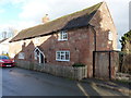
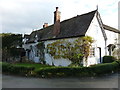
9
Old cottages near the church
Possibly these cottages were at one time one building, but the three front doors would seem to indicate that probably there are now two or three different dwellings here.
Image: © P L Chadwick
Taken: 18 Apr 2010
0.10 miles
10
16 Centre Place, Alveley
The other half of a pair of Grade II listed https://www.britishlistedbuildings.co.uk/101053195-16-and-17-centre-place-alveley#.WixGb9SLTGg cottages (granted in 1970) which date from the 18th century. The other one of the pair is at Image, and together they form part of a group of listed buildings in the historic middle of the village.
Image: © Richard Law
Taken: 3 Dec 2017
0.10 miles